Showing posts with label Galileo. Show all posts

Tuesday, September 21, 2010

Io Volcano of the Week: Isum

I apologize for my absence the last couple of weeks.  When you write a blog in your spare time, it exists at the pleasure of my other obligations, my health, and other demands on my spare time.  So when a busy period with work, a nasty cold, and Halo: Reach all hit in the same week, well, unfortunately this blog takes a bit of a back seat.  This week I am feeling much better, work is a bit quieter (wait, there is a Titan flyby on Friday, lalalalalalalalala, I can't hear you), and I have grown wary of Halo: Reach, so I can come back to my weekly series on Io's volcanoes.  Today, we are discussing Isum Patera, one of Io's more active volcanic centers and the likely source of the largest lava flow field on Io, Lei-Kung Fluctus.

First off, let's get the basics out of the way.  There really isn't a polite way to describe the shape of the volcanic depression that is Isum Patera; it looks like a sperm cell.  Isum is located at 29.82° North Latitude, 208.46° West Longitude. The head of the Isum "spermatozoa" is 62 kilometers (39 miles) in length and 43 kilometers (27 miles) in width.  The southern end of the patera appears to have a greater depth than the rest of the volcano, which can often be indicative of multiple collapses (if formed like terrestrial calderas) or sills embedded in different layers, however the low resolution of our best images of the region (1.3 kilometers or 0.8 miles per pixel), poor phase coverage, and the complex albedo patterns in the area precludes a clear analysis of the topography in this region.  A small mountain may lie along the eastern margin of Isum Patera, though this is difficult to confirm from available imagery.  The "tail" of Isum extends to the northeast from the northern end of Isum Patera.  The tail measures 184 kilometers (114 miles) long and 11 kilometers (7 miles) wide.  The floor of Isum Patera is generally dark green in color, similar to Chaac Patera, suggestive of chemically-altered basaltic lava, though a few spots along the tail of Isum Patera are much darker, more indicative of recent activity.

Isum lies at the center of a multi-colored region along the northern margin of Colchis Regio on Io's anti-Jupiter and trailing hemispheres.  The background color of the area is reddish-brown, typical for Io's plains at this latitude, but it might be enhanced by sulfur deposits from activity at Isum.  Green deposits dominate the terrain to the south and east of the head of Isum Patera, as well as on either side of its tail.  The margins of these deposits are digitate, or finger-like, which is more suggestive of a pyroclasic deposit that a lava flow field, which typically have lobate margins (see Lei-Kung Fluctus to the north of Isum in the image at left, for example).  The most intense of these dark pyroclastic deposits surround the tail of Isum Patera.  Their lack of chemical alteration that results from the interaction between sulfur and the iron in the pyroclastic material suggests they were laid down most recently.  More likely though, they are being covered by fresh material on a regular basis, as their dark albedo has been a constant since the Voyager encounters in 1979.

Volcanic activity has been detected at Isum Patera over a period of 31 years, since it was first observed in 1979 to as recently an adaptive optics observations at Keck Telescope on June 28, 2010.  The first detection of a thermal hotspot at Isum, indicative of on-going volcanic activity, came from the IRIS (Infrared Radiometer, Interferometer, and Spectrometer) instrument on Voyager 1.  It was detected again as a group of hotspots by Galileo's SSI camera when Io was in the shadow of Jupiter in June 1996, June 1997, and November 1997, every time the geometry was appropriate during one of the spacecraft's eclipse observations.  In each case two or three hotspots were detected: at the head of Isum Patera, in the tail, and in the southern portion of Lei-Kung Fluctus.  Galileo's Near-Infrared Mapping Spectrometer (NIMS) also detected a thermal hotspot at Isum Patera during every viewing opportunity during the Galileo Nominal Mission, between September 1996 and September 1997.  It was also seen at high resolution by NIMS in August 2001 (show at right) during a flyby of Io.  NIMS found a line of thermal emission within the middle portions of Isum's tail section.  The intensity of the emission was so great that the NIMS detectors saturated at most of the wavelengths the instrument looked at except the shortest (1.313 and 1.593 μm).  This suggests that both high-temperature volcanism and that large percentages of each pixel that covered the tail region were hot at the time of the observation.

Taken all together, what does the morphology of Isum Patera and its surrounding terrain and its history of persistent, high temperature volcanism with multiple hotspots tell us about the style of volcanic activity going on at Isum?  The distribution of dark pyroclastic material external to Isum and bright and dark patera within the tail region are most similar to Pele, a persistently and vigorously active lava lake.  The thermal emission history is also roughly similar.  In this case, the tail of Isum is a large lava lake whose crust is continuously overturned due to fresh material being brought into the lake from below.  This overturning, which can involve short lasting lava fountains, also permit the release of sulfurous gases and pyroclastic material.  This latter material can then be laid down as dark deposits on either side of Isum's tail.  The tail of Isum Patera may be a fissure that has opened up in Io's crust, allow magma to reach the surface and resupply the lava lake at Isum.  This magma could have also formed a sill at one end of the fissure, which was then later unroofed to form Isum Patera proper.  Another patera may also be located at the northeast end of the fissure, but it isn't clear.

However, some of the evidence can be deceiving.  The global scale images from Galileo that are available of this volcano reveal a curved dark line connecting the northern end of Isum Patera to the southern end of the massive Lei-Kung Fluctus, a large compound lava flow field more than 125,000 sq. km (48,000 sq. mi.) in size.  We know from SSI and PPR measurements from the Galileo spacecraft that at least the southern end of it was still active as of 2002.  A similar relationship between an active patera and a nearby active lava flow field, with a curved dark line between the two, has been noted at other Ionian volcanoes, most importantly at Amirani.  This suggests that Isum Patera may be the source of the largest lava flow field on Io.  In this case, the dark curved line is a lava tube that channels lava from its source in the tail of Isum Patera north to active flow lobes across Lei-Kung Fluctus.  I should point out that that given the huge extent of Lei-Kung, multiple sources can't be ruled out, and given the pattern of thermal emission seen by Galileo's Photopolarimeter-Radiometer (PPR), that's probably likely.

Today, we have looked at one of the most persistently active volcanoes on Io, Isum Patera.  Isum has a rather unique shape for an Ionian volcano.  Regardless, it is the site of rigorous but consistent activity that is suggestive of a large lava lake within the tail end of Isum Patera.  That doesn't preclude the possibility that Isum is also the source (or one of the sources anyway) of Lei-Kung Fluctus, which may act as a kind of release valve for the lava lake, where the overflow from the lake is deposited.

This article is making up for the one I intended to write last Monday so I still need to catch up.  Later this week we'll look at Maasaw Patera, a small volcano seen up close by Voyager 1.

References:
Radebaugh, J. (2005). "Formation and Evolution of Paterae on Jupiter's Moon Io". Ph.D. Dissertation.  University of Arizona.
Lopes-Gautier, R.; et al. (1999). "Active Volcanism on Io: Global Distribution and Variations in Activity". Icarus 140: 243–264. 

Monday, September 6, 2010

Io Volcano of the Week: Shamshu

Each week here on the Gish Bar Times, we profile one of Io's 400 active volcanoes as part of our volcano of the week series.  This week, we take a look at fairly dormant Shamshu Patera, a large patera, or volcanic depression, on Io's leading hemisphere.  If you haven't read it already, be sure to check out last week's volcano of the week, Tvashtar, which we covered in great depth over three articles (Part One - Part Two - Part Three).

As always, let's take care of the basics first about this volcano.  Shamshu Patera is located at 10.1° South Latitude, 63.0° West Longitude, or about 500 kilometers (310 miles) ESE of Hi'iaka Patera, a volcano of the week back in August.  The volcano measures 115 kilometers (72 miles) north-to-south and 107 kilometers (67 miles) east-to-west.  The height of the patera wall which marks the outer edge of the volcano is variable as the surrounding terrain is not constant, the result of debris flows coming off a mountain that abuts the northeastern margin of Shamshu Patera.  Shadow measurements along the northwestern wall of Shamshu show that it is 500 meters (1,640 feet) tall, however the lack of a shadow along portions of its western wall suggest that it maybe less than 50 meters (160 feet) tall in some areas.  Shamshu Patera was named at the IAU General Assembly in August 1997 after a pre-Islamic Arabian sun goddess.

Galileo's best images of Shamshu were taken on February 22, 2000 during its I27 encounter with Io.  I have reprojected the two images that covered Shamshu Patera into a two-frame mosaic, in a simple cylindrical projection with a scale of 350 meters (1,150 feet) per pixel.  This mosaic covers all of Shamshu Patera, right of center, as well as Shamshu Mons to the west and portions of two other mountains: one abutting Shamshu Patera to its northeast and another a little farther away to the southeast.  For a look of color in this region, see the map above as well as a global view from June 1997.

A few obvious features stand out about Shamshu Patera.  The volcano's floor is dominated by dark lava flows of varying albedos.  The different levels of brightness of its flows suggest that different eruptions produced new flow lobes that covered a different potion of its floor.  As the lava flows age, they cool and all more sulfur dioxide and sulfur to condense on their surfaces.  So as they age, the lava flows slowly brighten.  Despite how dark many of these lava flow lobes look, I can't see any evidence for surface changes at Shamshu during the Galileo mission, so either very little SO2 is deposited here, or they maybe persistently active.  More on that in a bit.  The shape of Shamshu's dark material, and the more central location in the patera, is more consistent with these resulting from lava flows rather than this volcano being a lava lake, like Pele or Loki.  About half of the patera of covered in material that has the same brightness as the surrounding Ionian plains and has a brighter orange color.  These areas likely haven't seen lava flows in recent times (> 100 years) or may have been coated in sulfur.

Just outside of the Shamshu's walls, a number of apparent bright flows are visible.  To the west of Shamshu, these bright deposits are correlated with the margins of the debris flow that came off the mountain to the northeast of the volcano.  That's right, I said margins, because layers are apparent within the edge of the debris flow.  The visibility of layers combined with the presence of bright material correlated with the scarps that mark the edge of these layers suggest that they are eroded by sulfur dioxide sapping.  The presence of layers in the debris flow (if that's what this is) would also mean that the landslide materials are remarkably well sorted with a mix of basalt/sulfur and sulfur dioxide layers.  A very bright flow is visible along the southern edge of Shamshu Patera, either the result of a sulfur flow, or, more likely, a silicate lava flow whose surface has been chemically altered.  Something odd is going on here because this flow is quite bright, so bright that from distant imaging, it almost looks like it should be the southern margin of Shamshu Patera.

As far as current volcanic activity, Shamshu was observed by the Galileo Near-Infrared Mapping Spectrometer (NIMS) as an active hotspot on only one occasion, during orbit C10 in September 1997.  The region was observed on several occasions before and since by Galileo and by New Horizons in 2007 and no additional activity was detected.

Next week, we will shift our focus from this fairly quiescent (at least in the present epoch) volcano to the more active Isum Patera on the opposite side of Io.

References:
Bunte, M.; et al. (2010). "Geologic mapping of the Hi’iaka and Shamshu regions of Io". Icarus 207: 868–886. 

Tuesday, August 31, 2010

Io Volcano of the Week: Tvashtar - Part Two

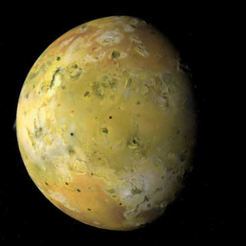
This week, for our series covering one Ionian volcano each week, we are taking a look at a large volcanic region in Io's north polar region, Tvashtar Paterae. Yesterday for part one, we took a closer look at some of the images Galileo acquired and the geology of this region.  In summary, Tvashtar Paterae is a string of four volcanoes that show various signs of recent or current volcanic activity.  Three of these volcanic depressions, or paterae, are surrounded by a U-shaped mountain that has been modified by sulfur dioxide sapping, forming canyons that cut as deep as 40 kilometers (25 miles) into the plateau, and slumping.  Today, we focus on the intense volcanic activity observed at Tvashtar during the Galileo mission, mainly between November 1999 and October 2001.  Tomorrow, we will focus on more recent volcanism at Tvashtar, including the outburst that accompanied the New Horizons flyby in February 2007.  We will also summarize what the eruption style at Tvashtar tells about how its lavas are fed.

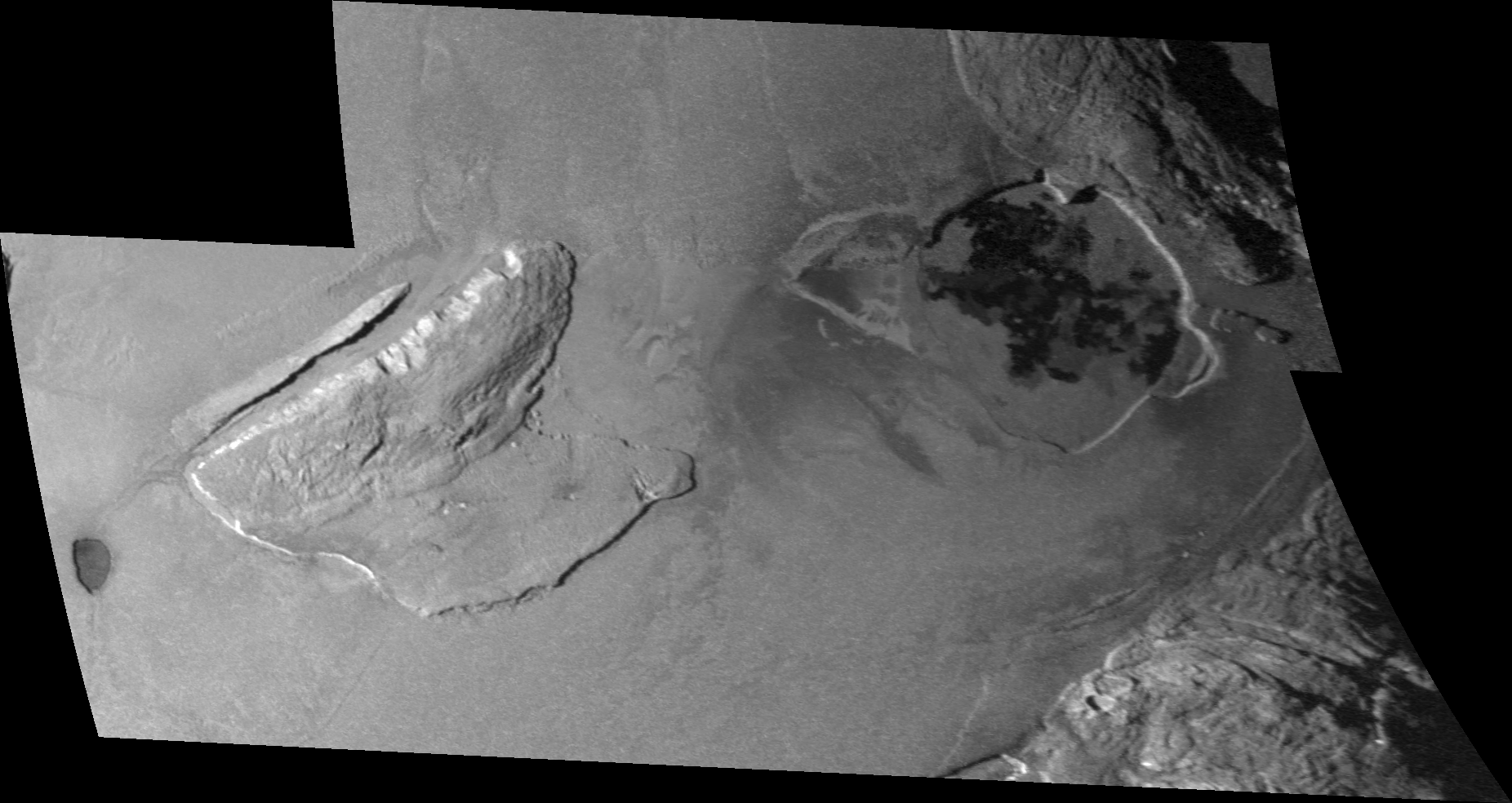
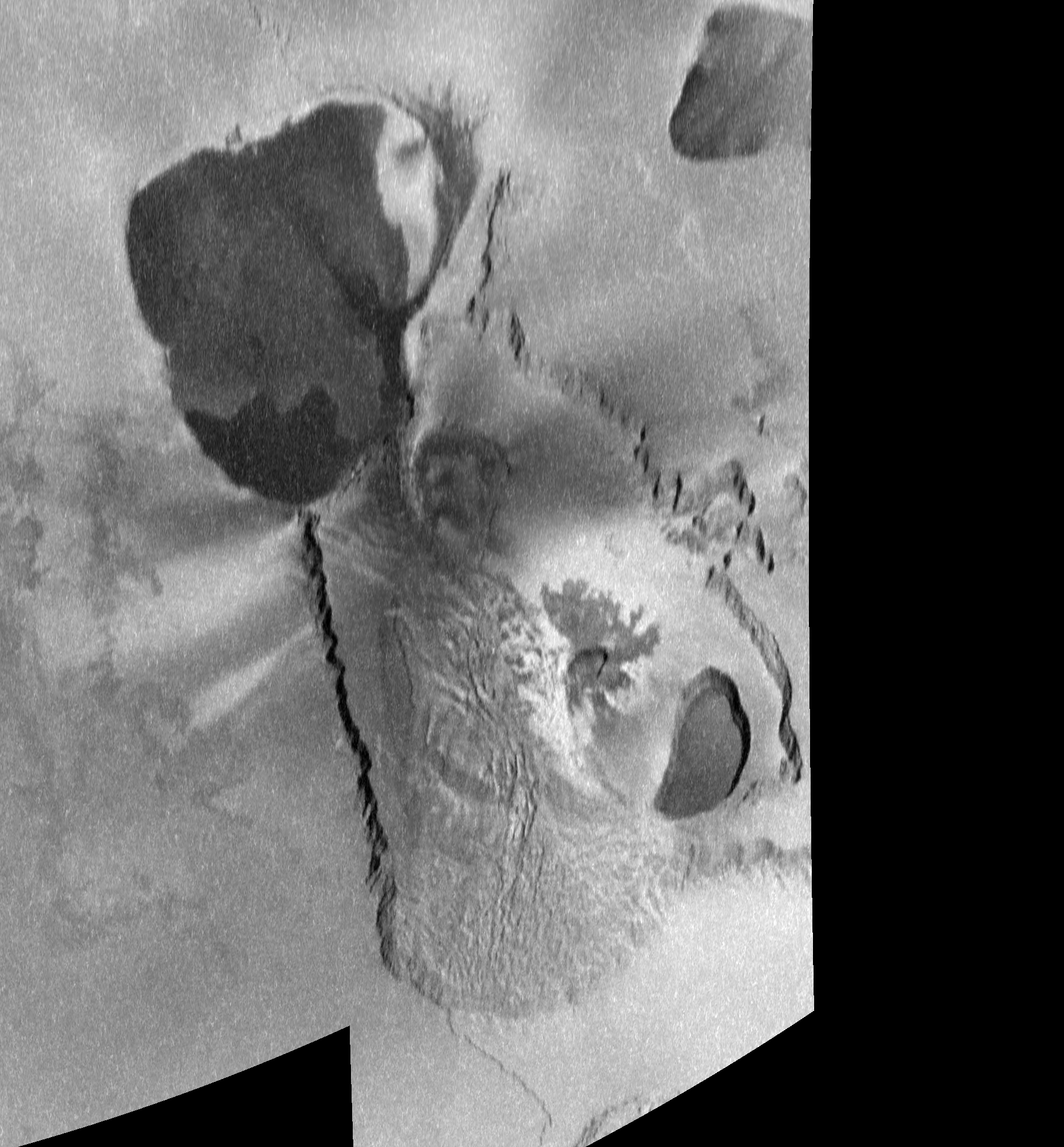
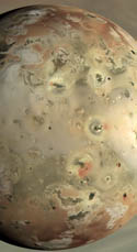
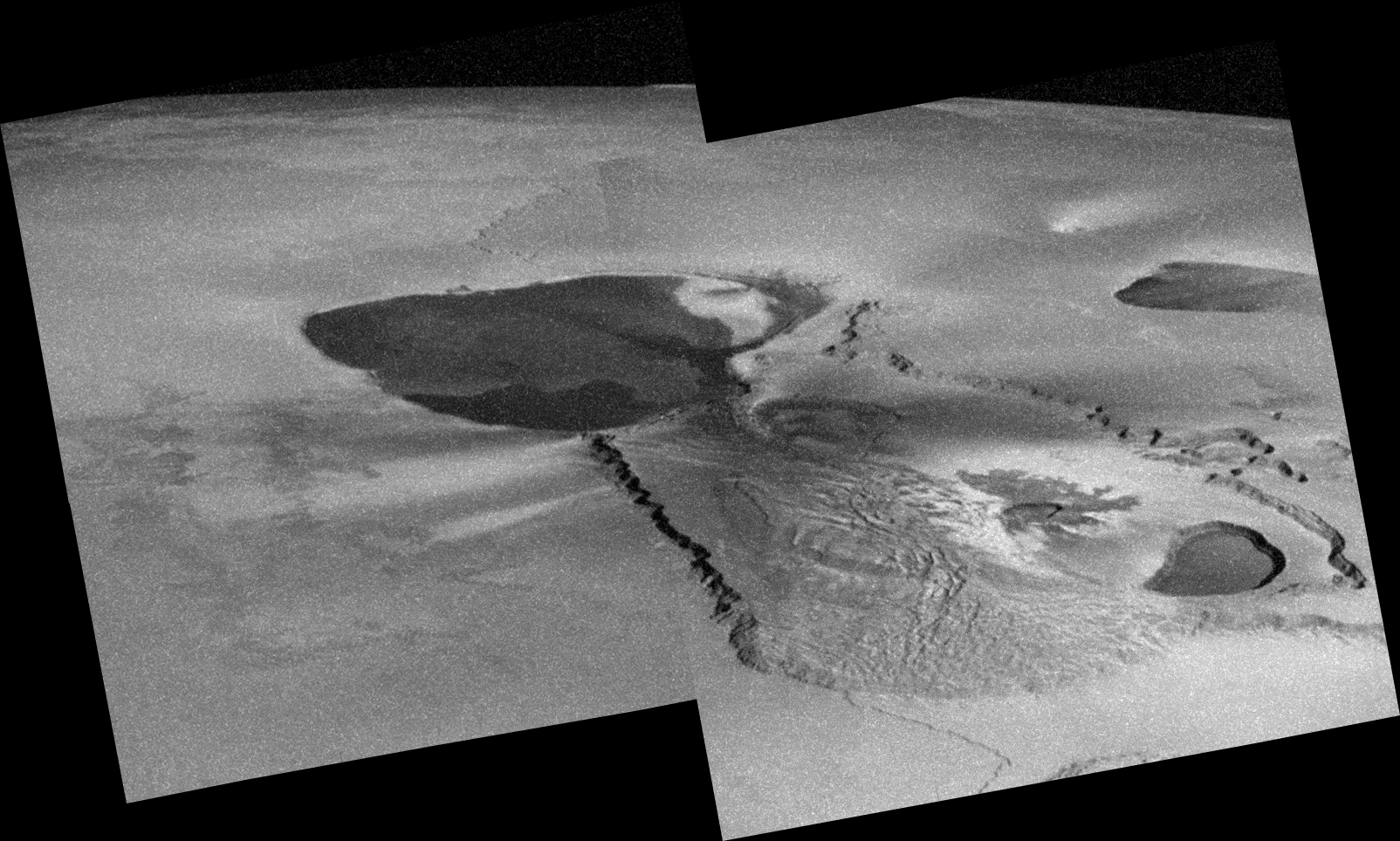
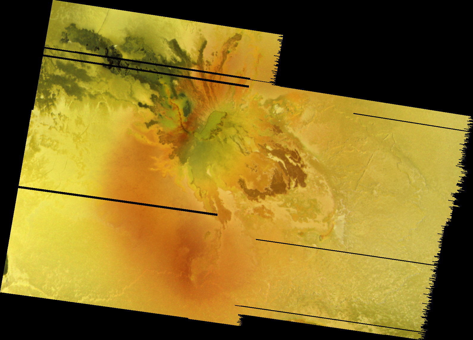
Before I continue, I should point out the image at above right.  I have labeled each of the four volcanoes at Tvashtar: A, B, C, and D.  I hope this reduces confusion over the next two articles about which volcano I am referring to.  So if I discuss an eruption at Tvashtar B, I am referring to the second volcano from the left.  Tvashtar A is the large, heart-shaped volcano with the whale-shaped lava flow/lake on the northwest end of Tvashtar Paterae.  Tvashtar C is the small patera with the faint lava flows that radiate out to its north and east.  Tvashtar D is the steep-sided, kidney-shaped patera with a dark lava flow covering its southern half on the southeastern end of Tvashtar Paterae.

Million-to-one shot, Doc.  Million-to-one.

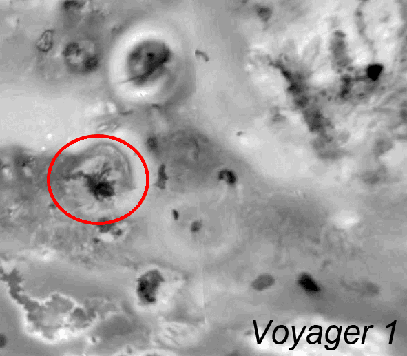
It is hard to believe now after more than 10 years of observing various Tvashtar eruptions that prior to the outburst eruption of November 1999, a faint thermal hotspot, resulting from an excess of near-infrared energy being emitted by cooling lava flows, was seen at Tvashtar on only two occasions: by the Galileo SSI camera in April 1997 when the moon was in Jupiter's shadow and by Franck Marchis and his colleagues at the European Southern Observatory (ESO) on September 30, 1999.  Over the period between the Voyager flybys in 1979 and the Galileo encounter with Io in November 1999, there doesn't appear to be any evidence for surface changes in and around Tvashtar Paterae.  There were a few patches of dark material seen in color data acquired in July 1999 that represent lava flows or lakes that were active before then, including two dark regions in Tvashtar A, a 25-kilometer (16-mile) long L-shaped flow in Tvashtar B, and a dark region covering the southern half of Tvashtar D.  So volcanism was a common geologic process at Tvashtar, but during the Galileo mission and perhaps during the 16 years leading up to it, the region had been largely dormant except for a pair of small, precursor eruptions.

Tvashtar's dormancy came to a crashing halt on November 26, 1999. In conjunction with the Galileo flyby of Io occurring that day, Bob Howell of the University of Wyoming used the NSFCAM at NASA's Infrared Telescope Facility (IRTF) in Hawaii to image Io a few hours after Galileo's encounter.  His images revealed a bright hotspot at Tvashtar, one of a rare class of intense outburst eruptions.  Images taken by Franck Marchis and his group at ESO and infrared photometry taken at the IRTF and the Wyoming Infrared Observatory (WIRO) revealing only a faint hotspot at Tvashtar provide time constraints for the start of the eruption to sometime after November 24.  Howell estimates that such eruptions are occurring 2–4.5% of the time somewhere on Io.  Assuming that the most intense period of a volcanic eruption on Io last approximately two days before calming down, this suggests that approximately six such eruptions occur each year somewhere on Io.  At least two others were observed by ground-based observers in 1999: at Grian Patera in June and at either Tawhaki or Gish Bar in August.  So the chances that Galileo would be able to image an eruption such as these at high resolution without knowing where an eruption might occur, given the amount of coverage it acquired during an individual flyby (~2–4% of the surface), were pretty slim.

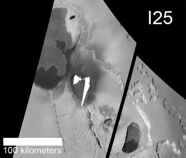
However, it just so happened that the Galileo imaging team had targeted Tvashtar for a two-frame mosaic during Galileo's I25 encounter on the day of the most intense period of the eruption.  More luck came when Galileo engineers were able to send up commands quickly enough to bring the spacecraft out of safe mode before the Tvashtar observation was to be taken.  The safing event also ensured that there would be enough downlink time to return all of the images in this mosaic, as the higher-priority, high-resolution observations were not taken.  These images were returned in early December and revealed a pair of over-exposed streaks along the northern margin of Tvashtar B.  These streaks resulted from bleeding in the CCD detector array in Galileo's SSI camera.  Based on their knowledge of how this type of camera overexposure occurs, Galileo imaging scientists were able to reconstruct the geometry of the exposed, hot lava that caused it.  Assuming that the fissure it originated from was roughly linear, they estimated that the bleeding area was caused by the intense thermal emission from a curtain of lava that reached 1.5 kilometers (5,000 feet) into the cold, Ionian sky.  This lava curtain, or line of lava fountains, was split into two main sections along the western and eastern halves of a 25-kilometer (16-mile) long fissure vent that runs along the northern edge of the floor of Tvashtar B.  Considering the global rate of outburst-class eruptions (~3-6 eruptions with a VEI > 4–5), it was incredibly fortuitous to observe at high resolution such a rare class of Ionian eruption.

To better understand how this bleeding occurs and how they were able to estimate the height of the lava curtain, let's use some *shock* horrible, over-used analogies. Imagine that each of the 640,000 pixels of the Charged-coupled detector (CCD) on Galileo's camera is like a bucket that you fill with photons, which are converted to electrical charge in the bucket.  The number of photons it takes to fill the bucket (pixel, or DN, value of 255 in an 8-bit camera) is defined by the observation's gain state (lower gain states mean fewer photons can fill the bucket, higher gain states require more), and the time you leave the bucket out to be filled is defined by the exposure time.  Filter selection and the sensitivity of the silicon the CCD was made out of constrains the types of photons (wavelengths) you allow in the bucket.  When the bucket is filled with so many photons that it overflows, or saturates, photons pour out into the buckets, or pixels, above and below it in the detector array.  How this overflow or bleeding develops was determine through calibration of the camera system.  For every bucket or pixel above the original over-exposed pixel that is itself overflowing, nine pixels are filled below it.  The longest column of bleeding consisted of 94 pixels, and taking into account the lava flow below the fissure, Milazzo et al. 2005 found that 11–16 of those pixels covered the lava curtain and flow.  Milazzo et al. estimated that the lava fountains on the western end of the fissure, least contaminated by the presence of a lava flow on the ground, were 360–900 meters (1,180–2,950 feet) tall.

Adding up all the electric charge caused by the intensity of photons from this eruptions and the exposure time of the image, they found an electron flux, corresponding to the rate at which photons filled those pixels, of between 0.94 and 1.8 × 10⁸ e- pixel-1 s-1, which corresponds with lower limit on the brightness temperature of 13001350 K.  Similar brightness temperatures were detected at the western end of the fissure.  Spectra from the Near-Infrared Mapping Spectrometer (NIMS), taken as the instrument rode along with the SSI mosaic observation, also covered a portion of the lava curtain, though much of their data over the eruption was also saturated.  Using a non-saturated pixel in Tvashtar B, Lopes et al. 2001 found a color temperature for the hot component of 1060 ± 60 K.  This was considered a lower limit since the unsaturated pixel used did not cover the hottest areas seen by SSI, other NIMS pixels that were saturated likely covered areas that were hotter, and the influence of reflected sunlight all cause measured temperatures to be underestimates.

Tvashtar: Master of its (thermal) domain

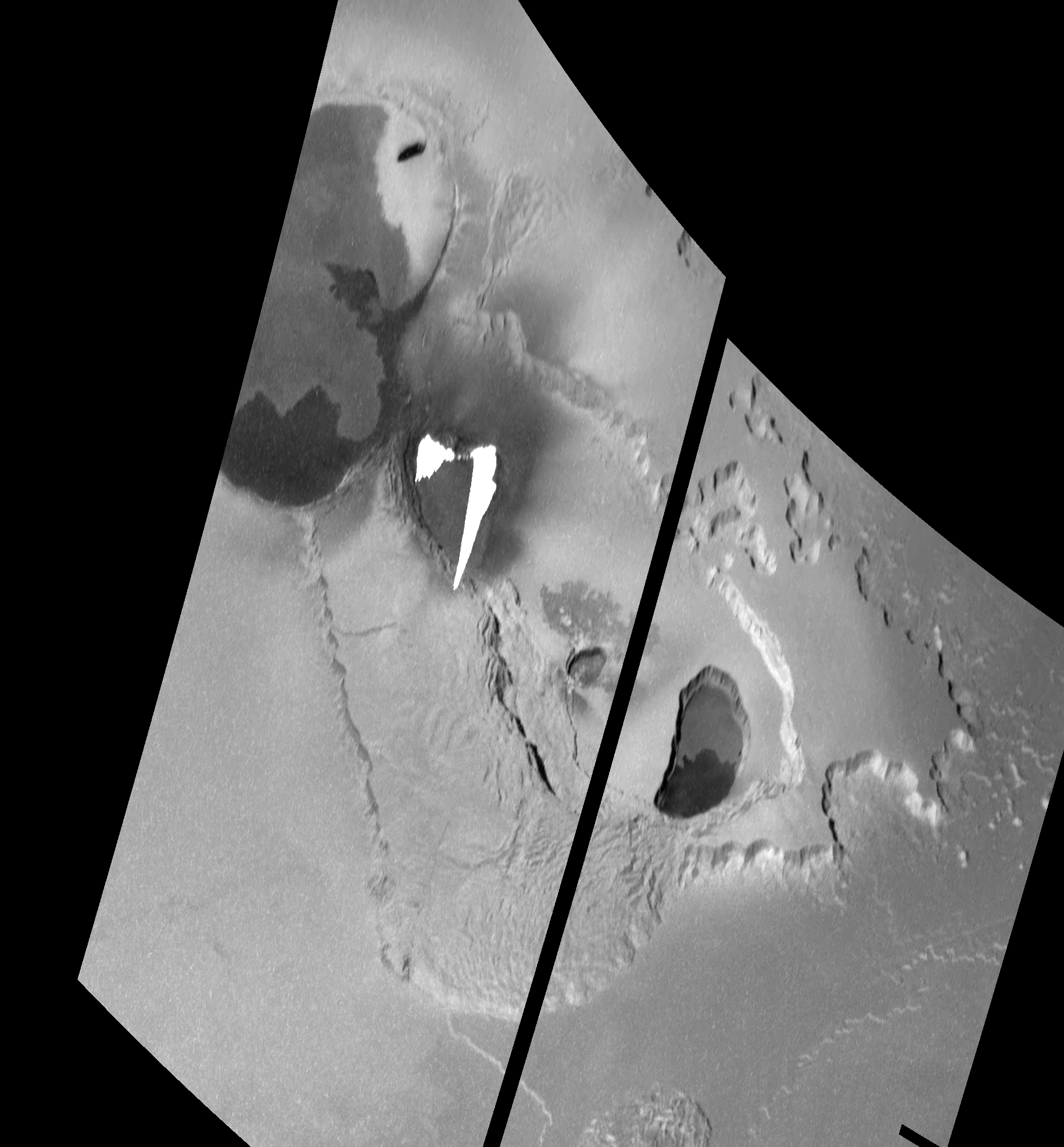
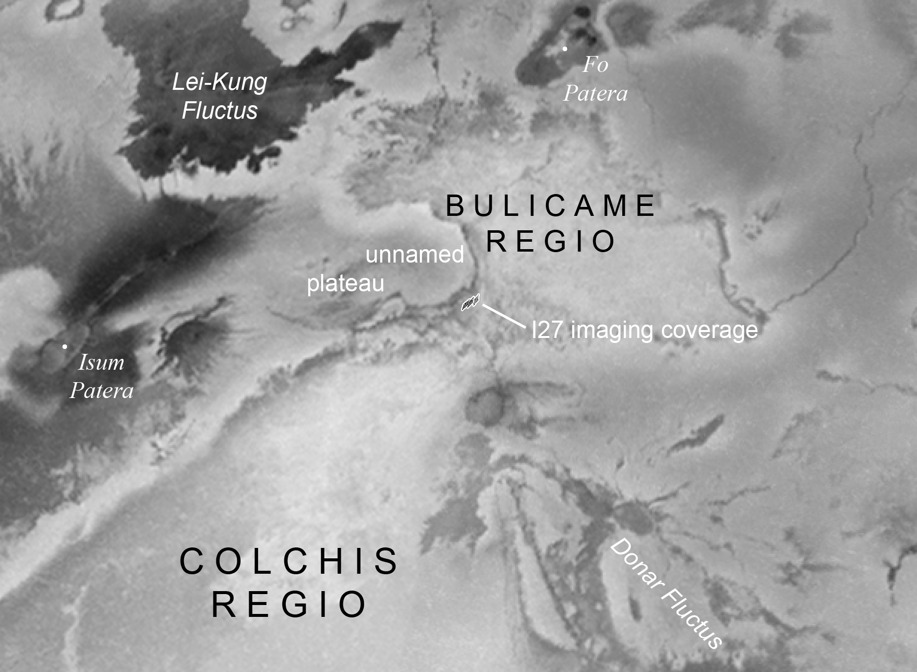
To follow up on the November 1999 observation of an outburst at Tvashtar, an eruption they could pin down to a specific date, 
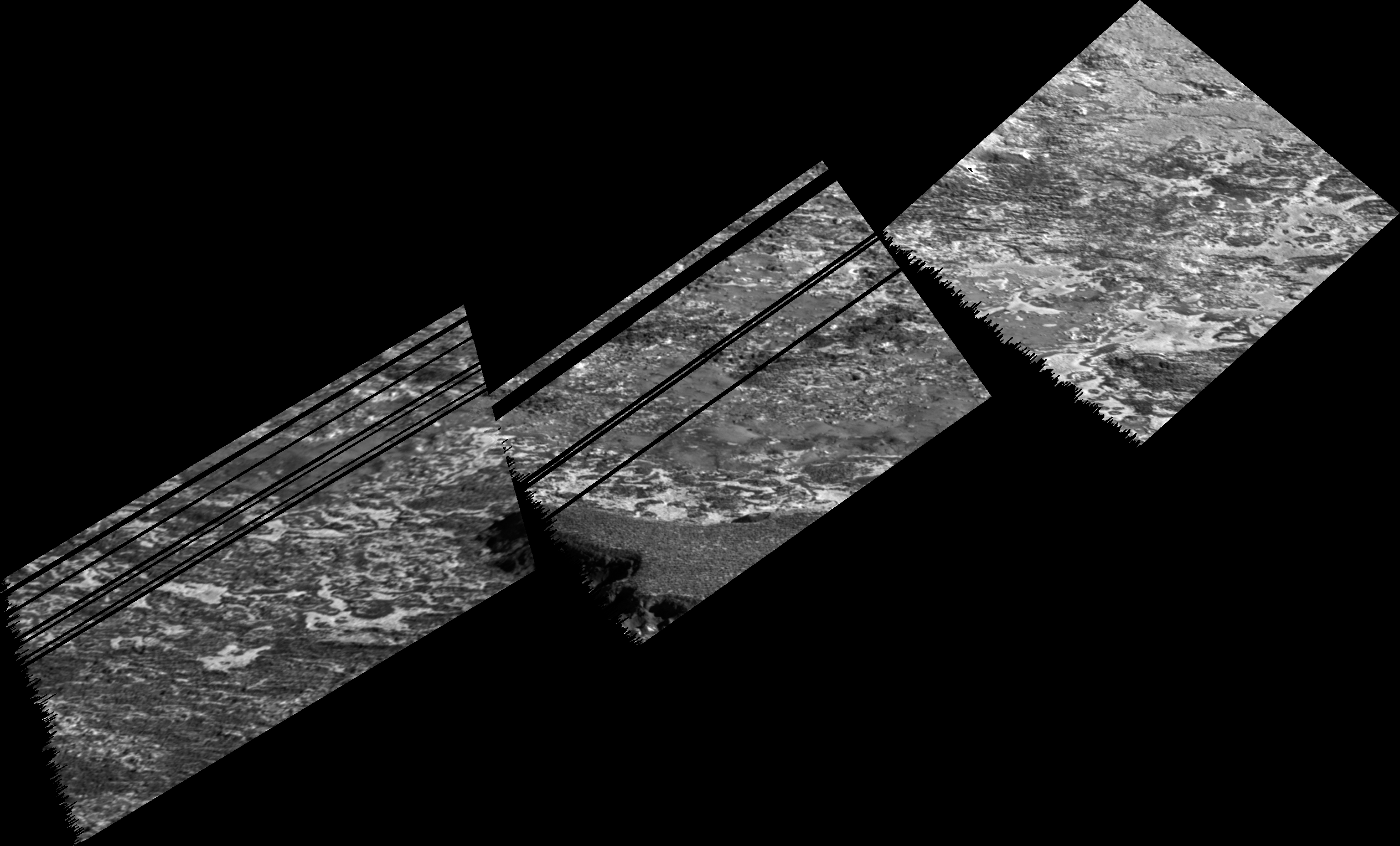
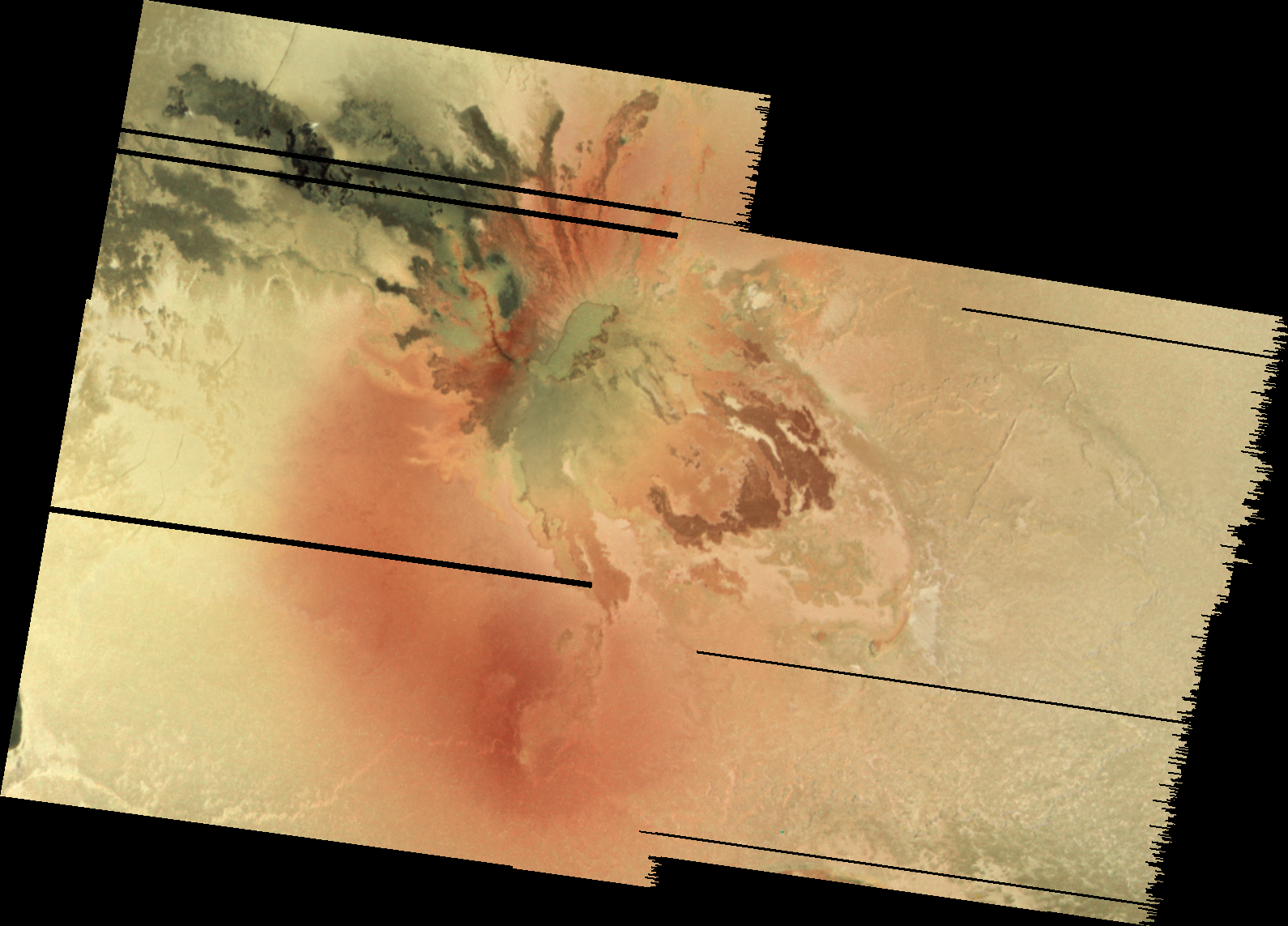
Galileo observed Tvashtar during an encounter on February 22, 2000 (also known as I27) using images with a scale of 315 meters (1,033 feet) per pixel.  This observation used five images at different filters (violet, clear, 756 nm, 889 nm, and 968 nm) to measure lava temperatures more accurately than was possible in the I25 data and to determine the silicate composition of the lava by looking for an absorption band around 900 nm that is thought to be formed by orthopyroxene, a mineral found in basalt and other mafic igneous rocks.  A composite of these images is shown at right.  As you can see, the activity at Tvashtar B had largely shut down, leaving behind a dark lava flow that matches the appearance of an older flow seen before the eruption.  This is confirmed by color temperatures measured by NIMS of between 500 and 600 K, indicative of cooling silicate lava and/or very small exposures of fresh lava.

While B had quieted down, Tvashtar A had heated up.  Images acquired using filters that were sensitive to near-infrared light revealed glowing lava within much of a whale-shaped lava flow that runs along the southern and eastern end of Tvashtar A.  These thermal hotspots were not seen in the clear-filter data in November 1999.  Small glowing hotspots were also visible at the end of each of the flukes of the "whale" (note to John Spencer: I think it looks like a whale, and since this is my blog, I can say it looks like a whale, so there :-p ).  These hotspots are possibly the source of the lava that is seen glowing at a cooler temperature farther south and west.  Milazzo et al. 2005 measured a color temperature of at least 1220 K for these small hotspots.  Farther south and west, the dark region within Tvashtar A glowed to the point that it saturated the camera's detector in places in the 889 nm and 968 nm filter images.  This shows up as the red and orange area within the flows in the image above.  Milazzo found a mean temperature of the unsaturated pixels in this region to be approximately 1300 K, though higher temperatures or greater fractional areas (the more likely of the two) is possible in the saturated pixels.  Given the high temperature of this large region, a cooling lava flow is unlikely.  Milazzo suggests that this area maybe a lava flow that is fed by lava tubes and flows mostly below a cooled lava crust, in which case the thermal emission observes comes from sub-pixel skylights, or the area is one big lava lake that is only intermittently active.  I know Moses favored the lava lake hypothesis, but in reality, a mixture of eruption styles was likely.

Tvashtar remained active into late 2000 when Galileo and the passing Cassini spacecraft made joint observations Io and the Jovian system.  While Cassini observed Io from ten times farther away than Galileo, the increased wavelength coverage its camera provided allowed researchers to observe more gas-rich plumes, like Pele's, as well as detect a thermal hotspot at that volcano.  Using such images taken at ultraviolet wavelengths, a large volcanic plume with a height of 385 kilometers (240 miles) was observed over Tvashtar Paterae by the Cassini ISS.  This corresponds with a red oval plume deposit, seen in Galileo images taken on December 30, 2000, that encircles Tvashtar.  This deposit is quite similar to the one that surrounds the volcano Pele, and suggests that the plume was enriched with elemental sulfur enough to form an optically thick layer of S4 on the surface.  This plume accompanied yet another intense, outburst eruption, observed from Earth by Marchis et al. using the adaptive optics system at the 10-meter Keck II telescope in Hawaii.  Tvashtar remained active in observations from Keck taken on February 19, 2001, but it was less energetic than it was in December 2000.  The area and temperature reported by Marchis et al. 2002 was consistent with a cooling lava flow with only a moderate amount of new activity, relative to the intense, lava fountain-enhanced eruptions seen in November 1999 and December 2000.

During the next two Io flybys on August 6 and October 16, 2001, Galileo took advantage of several opportunities to image Tvashtar up-close in the wake of these intense eruptions.  The best of these two flybys for observing Tvashtar was the first (I31) as the spacecraft flew nearly directly over the volcano at an altitude of 300 kilometers (186 miles), within the plume seen by Cassini.  Two very-high-resolution observations were planned by Galileo SSI during the encounter: a 6-frame mosaic at 3-5 meters (10-16 feet) per pixel across the I25 vent region in Tvashtar B and its northern patera wall and a 6-frame, context mosaic at 50 meters (164 feet) per pixel that covered Tvashtar B and portions of Tvashtar Mensae to its north.  Unfortunately, due to a camera anomaly, these observations were lost.  
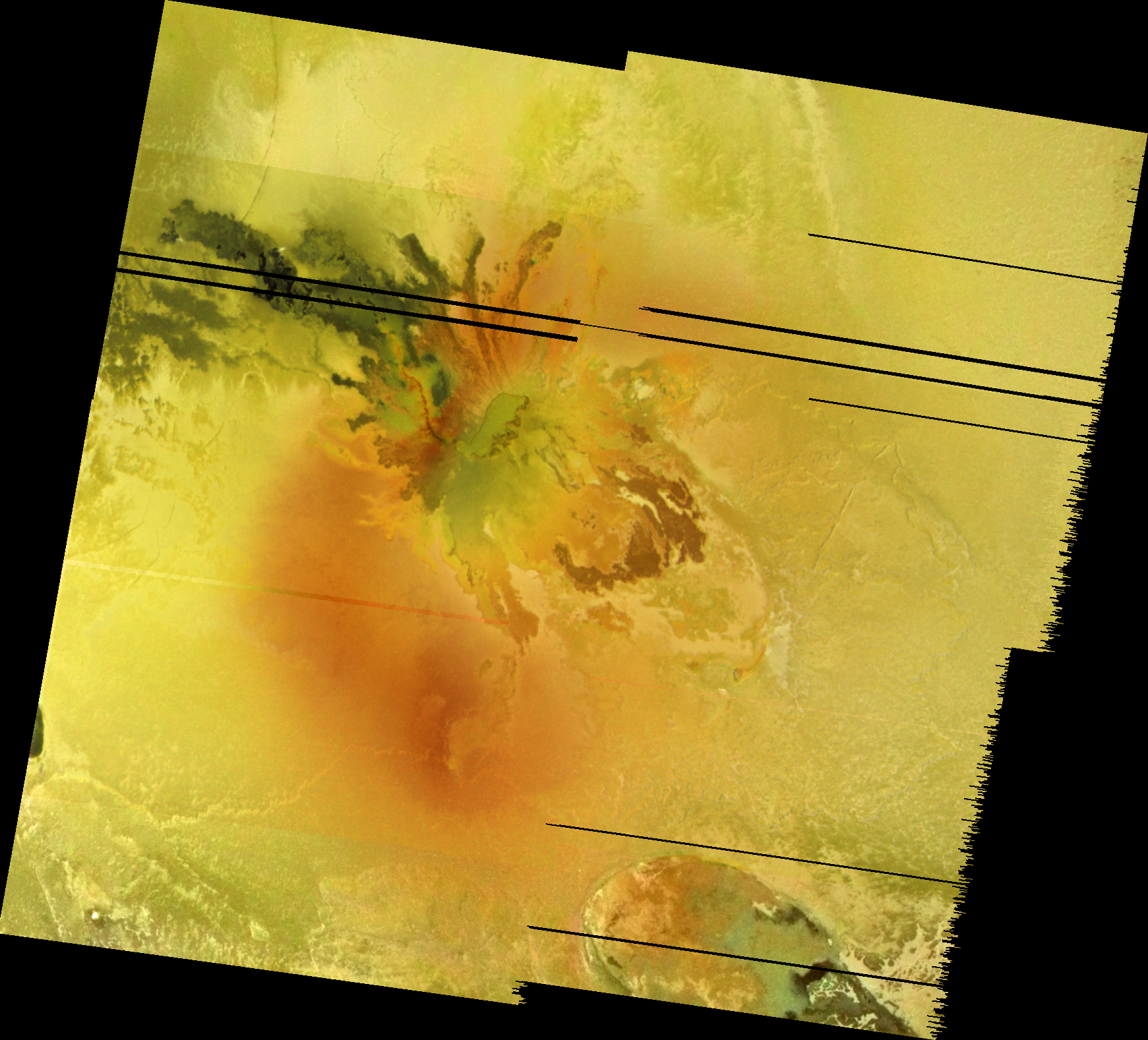
Low-resolution global images at 19.6 kilometers (12.2 miles) per pixel showed that the plume deposit encircling Tvashtar that 
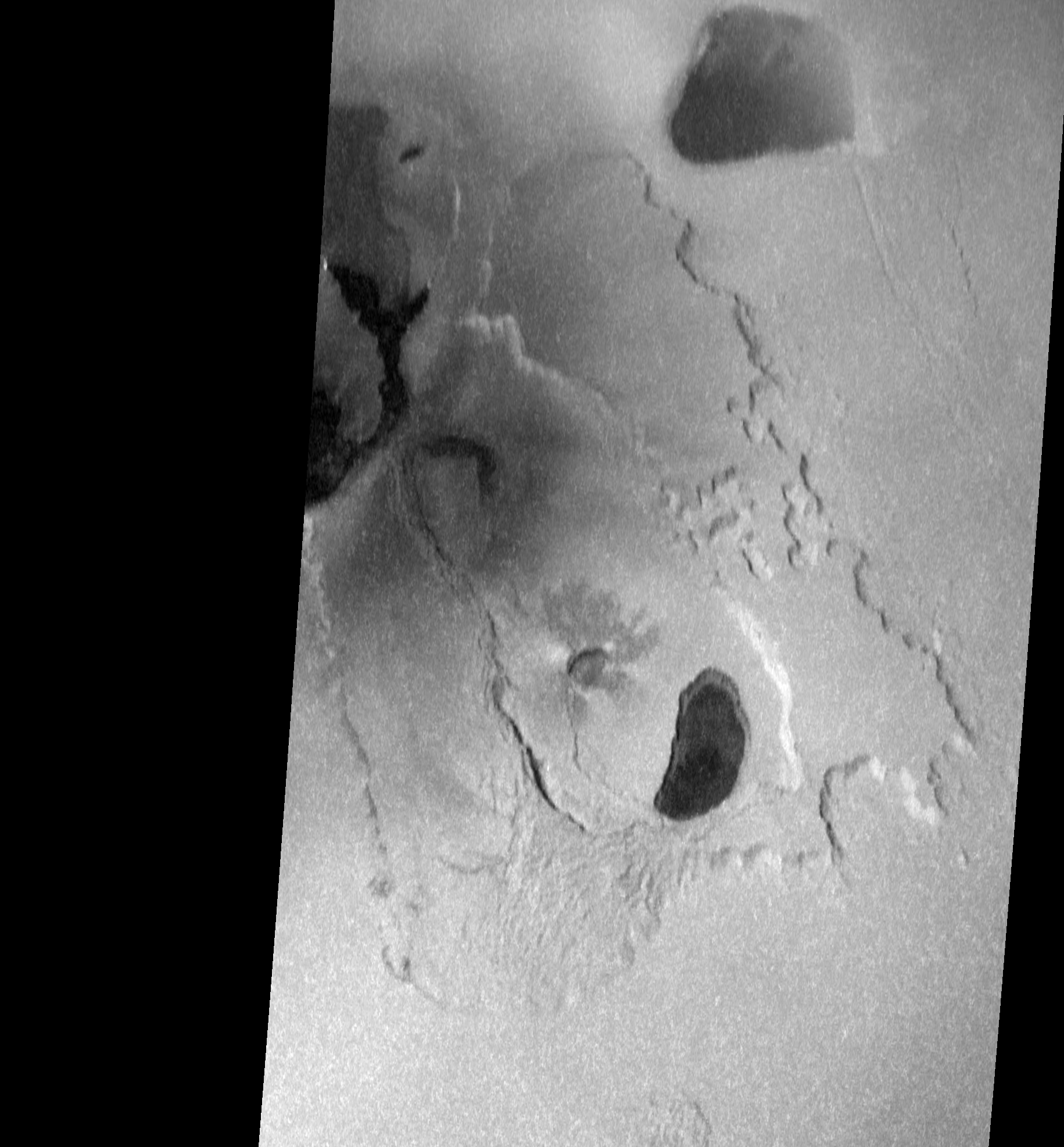
Galileo observed in December 2000 had faded quite a bit due a mix of relative inactivity and deposits from a fresh eruption at Thor to the southwest of Tvashtar.  NIMS was not affected by the SSI anomaly and took high quality data over Tvashtar during this encounter. This observation revealed the complex distribution of warm lava and pyroclasts across the Tvashtar portion.  The main red hotspot in the data shown at above left corresponds with the likely source for the December 2000 plume and lava fountains along the southwestern wall of Tvashtar B.  Two additional hotspots are visible at the lava flow that formed during the November 1999 eruption and along the northeastern margin of Tvashtar A.  Fainter flows were also detected from the whale-shaped flow in Tvashtar A and from Tvashtar C.

Galileo's final opportunity to image Tvashtar came on October 16, 2001 during its I32 flyby of Io.  This time Galileo flew over Io's south polar region, leaving only an opportunity to image Tvashtar at a more oblique angle later in the flyby.  The resulting two frame mosaic, at 200 meters (656 feet) per pixel, does reveal changes that occurred at Tvashtar as a result of the December 2000 volcanic eruption.  These include a fresh lava flow across portions of Tvashtar B, likely forming during the eruption seen by Cassini and fresh pyroclastic deposits to the east and southwest of that patera.  The extent of these dark deposits is consistent with the type of volatile-rich volcanic eruption that would also spawn a 400-kilometer-high, sulfur-rich, volcanic gas plume.  New dark material was also seen along the northeastern edge of Tvashtar A, the site of a NIMS hot spot in August 2001.  This suggest that volcanic activity had gotten going in the interval between the I27 and I32 SSI observations there as well.  The distribution of this fresh dark material with a new pyroclastic deposit as it appears to cover both the edge of the patera floor and the terraced wall above it, though the NIMS observations suggests that at least some lava flowed out from this vent.  Finally, the dark lava flows that covered the southern half of Tvashtar D had pretty much faded by October 2001.

The Tvashtar region endured a series of violent volcanic eruptions between November 1999 through at least December 2000, and Galileo and Cassini had front row seats to the action.  Galileo observations from the SSI camera and NIMS spectrometer indicated that volcanic activity in the region was waning throughout 2001, with much of the thermal emission coming from older, cooling lava flows, though some fresh activity was likely at Tvashtar B and in parts of Tvashtar A and C as late as August 2001.  However, by December 2001, ground-based observations from Keck showed that Tvashtar had quieted down to the point that it was no longer detectable using their instruments.  However, that was not all she wrote for Tvashtar.  As we will see tomorrow, there are third and fourth acts for Io's volcanoes as we examine observations of Tvashtar from ground-based telescopes and the New Horizons spacecraft after Galileo's mission ended.  Tomorrow, we will also discuss what the various eruption styles at Tvashtar tells us about how its lavas are fed.

References:
McEwen, A. S.; et al. (2000). "Galileo at Io: Results from High-Resolution Imaging". Science 288 (5469): 1,193–1,198.
Keszthelyi, L.; et al. (2001). "Imaging of volcanic activity on Jupiter's moon Io by Galileo during the Galileo Europa Mission and the Galileo Millennium Mission". Journal of Geophysical Research 106 (E12): 33,025–33,052.
Lopes, R. M. C.; et al. (2001). "Io in the near infrared: Near-Infrared Mapping Spectrometer (NIMS) results from the Galileo flybys in 1999 and 2000". Journal of Geophysical Research 106 (E12): 33,053–33,078.
Howell, R. R.; et al. (2001). "Ground-based observations of volcanism on Io in 1999 and early 2000". Journal of Geophysical Research 106 (E12): 33,129–33,139.
Marchis, F.; et al. (2001). "A survey of Io's volcanism by adaptive optics observations in the 3.8-μm thermal band (1996-1999)". Journal of Geophysical Research 106 (E12): 33,141–33,159.
Marchis, F.; et al. (2002). "High-Resolution Keck Adaptive Optics Imaging of Violent Volcanic Activity on Io". Icarus 160: 124–131.
Porco, C.; et al. (2003). "Cassini Imaging of Jupiter’s Atmosphere, Satellites, and Rings". Science 299 (5612): 1,541–1,547.
Turtle, E.; et al. (2004). "The final Galileo SSI observations of Io: orbits G28-I33". Icarus 169: 3–28.
Milazzo, M.; et al. (2005). "Volcanic activity at Tvashtar Catena, Io". Icarus 179: 235–251.
Lopes, R.; et al. (2004). "Lava lakes on Io: observations of Io’s volcanic activity from Galileo NIMS during the 2001 fly-bys". Icarus 169: 140–174.

Io Volcano of the Week: Tvashtar - Part One

It is four for the price of one for this week's Io Volcano of the Week: Tvashtar Paterae.  During the month of August, we have examined the five volcanoes that were imaged up-close by the Galileo spacecraft during its encounter with Io on November 26, 1999.  During that flyby, Galileo acquired five observations with a scale of 160-280 meters or 525-920 feet per pixel (higher resolution observations were lost due to a spacecraft safing event).  Thus far we have profiled Zal, Emakong, Hi'iaka, and Culann, active volcanoes seen across various parts of Io's leading hemisphere.  This week, we travel to the great red north to Io's camera-loving volcano, Tvashtar Paterae.  Due to the sheer amount of data acquired of and papers written about just this one volcanic region, I am going to split this discussion up in to (at least) three parts.  Today, we will examine the geology of Tvashtar Paterae and the surrounding region, as well as the imagery Galileo returned of this volcano.  Tomorrow, August 31, we will focus on the eruptions that occurred at Tvashtar during the Galileo mission.  Finally, on Wednesday, September 1, we will examine the volcanic eruptions that have occurred there since the end of the mission, including the massive one that happened during the New Horizons flyby, and what these various eruptions tell us about how Tvashtar's lavas are supplied.

First, let's stick to the basics. Tvashtar Paterae is a chain of volcanic depressions located at 62.76° North Latitude, 123.53° West Longitude, placing it in the high northern latitudes of Io's anti-Jovian (i.e. the "far" side) and leading hemispheres.  All together, Tvashtar measures 306 kilometers (190 miles) from its northwest to southeast ends.  The volcanic region is named after Tvastar, a solar deity and blacksmith to the gods of the Vedic religion.  Tvastar crafted, like Hephaestus for Zeus in Greek mythology, the thunderbolts of Indra and other magical implements.  There are a number of Ionian volcanoes named after characters from Vedic and Hindu religious texts, such as Savitr (a large volcanic depression 300 kilometers, or 186 miles, south of Tvashtar), Surya, Vivasvant, Arusha, and Agni. Originally, the region was named Tvashtar Catena in 2000, using the IAU term for a string of craters, but that feature type was deprecated for Io in 2006, so the descriptor term was changed to the plural of patera (technically, an irregular depression, but used for Io as a geologic term for a volcanic depression).

Images

Before we get to the geology of Tvashtar Paterae, let's take a look at the available imagery, which you will see a lot of over the next few days on this blog.  While it was clearly visible in global-scale images taken by the Voyagers and Galileo before (including the C21 global color mosaic, a portion of which is shown at the top of this article), Tvashtar was first imaged up-close on November 26, 1999 during Galileo's I25 flyby.  This two-frame mosaic, with a scale of 183 meters (600 feet) per pixel, was originally designed as a 2 frame-by-4 frame mosaic that covered both Tvashtar and Savitr Patera to the south.  The goal was to better understand the geology of giant paterae (i.e.  volcanic depressions) that appeared to be common across Io's polar regions.  Based on measurements made by Jani Radebaugh and her colleagues and published in 2001, the paterae at high latitudes are larger but less numerous, and these two large depressions were thought to be typical of this.  Their eruption style also seemed to differ from volcanoes observed at lower latitudes.  25ISGIANTS01 was trimmed down to a 2-frame mosaic covering only Tvashtar Paterae in late October 1999 after the I24 flyby when the malfunction of the camera's summation mode meant that fewer frames could be taken given the available downlink.  Frames also had to be cut because of the decision to use pre-downlink compression off the tape recorder, rather than the camera's on-board compression, for some of the images taken.  The observation was returned slowly during December 1999, revealing a violent new eruption in the Tvashtar region.

As a result of the eruption there, Tvashtar was targeted for imaging on three of Galileo's four remaining Io flybys, in order to look for new activity and to monitor the region for surface changes.  The two datasets that made it back it to Earth include a five-color observation from the I27 encounter (February 22, 2000) and a two-frame, clear-filter mosaic from the I32 flyby (October 16, 2001).  The first observation, 27ISTVASHT01, has a scale of 315 meters (1,033 feet) per pixel, while the second, 32ISTVASHT01, has a pixel scale of 200 meters (656 feet).  Higher resolution imaging was planned for an encounter in August 2001, however they were lost due to a camera anomaly.  These included a very high resolution mosaic that would have covered the I25 eruption site and nearby patera wall at 3-5 meters (10-16 feet) per pixel.

   
25ISGIANTS01 - 11/26/199927ISTVASHT01 - 02/22/200032ISTVASHT01 - 10/16/2001
The three returned data sets are shown above.  Each has been reprojected to an orthographic map projection centered on Tvashtar.  The scale is 200 meters (656 feet) per pixel.  Finally, the resulting mosaics were cropped so that they cover the same area to make comparisons easier.

Geology

Tvashtar Paterae is not a single volcano, but a chain of four separate volcanic centers.  A rough schematic based on the three data sets is shown at right.  Orange lines mark the margins of volcanic depressions.  Blue lines mark the edges of plateaus, while green lines mark the visible edges of landslide debris deposits.  From this image, we can see that Tvashtar can be broken up into roughly two parts.  The northern end of Tvashtar consists of a large, 145×105-kilometer (90×65-mile), heart-shaped depression and is located at 64.7° North Latitude, 127.0° West Longitude.  This low-depression is host to a large area of dark material, with the darkest of this distributed in a whale-shaped region along the southern and eastern margin of the patera, though an additional very dark region was also seen in the western portion of the patera in July 1999, but had brightened by October 2001.  The green color of the rest of the dark terrain of this patera suggest that it consists of older lava or pyroclasts that have been modified chemically by infalling sulfur and sulfur dioxide, creating a film of iron sulfide.  High-resolution color observations from I27 revealed a bright deposit along the northeastern wall of this patera, possibly resulting from sulfur dioxide sapping, a geologic process we will encounter often as we explore the geology of Tvashtar, or fumaroles.

The southern end of Tvashtar consists of a 196×70-kilometer (121×44-mile), footprint-shaped region that is almost entirely enclosed by a low, U-shaped plateau named Tvashtar Mensae.  This area may be closed off by a patera wall to the northwest as well, but it is not clear if this region is lower than the local Ionian plains.  I do not consider this in-and-of-itself a separate volcano.  Nested within this region are three smaller paterae, each with signs of recent volcanic activity.  Going from west to east, the first nested patera is located at 62.5° North Latitude, 123.2° West Longitude and is 49 by 32 kilometers (30 by 20 miles) in size.  A fissure along the northern margin of this volcano was the site of violent volcanic eruptions in November 1999 and February 2007.  Lava flows associated with the 1999 eruption, earlier eruptions over the same place (if you look at the July 1999 images) and later eruptions are visible on the patera floor.  This patera is surrounded by a dark (occasionally dark green) pyroclastic deposit that reaches out at least 30 kilometers (20 miles) from the edge of the volcano.  The area covered by this deposit grows and shrinks in places over the period from 1999-2001, suggesting that volcanic activity leaves behind these deposits in the present epoch and sulfur dioxide released by sapping from the base of Tvashtar Mensae obscures some of it over time.

The second volcano is located at 60.6° North Latitude, 120.4° West Longitude and is 14 by 8 kilometers (9 by 5 miles) in size.  This patera is surrounded by digitate lava flows, suggesting that in the past it filled with lava and overflowed onto the surrounding landscape, mostly to its north and east.  Finally, the third patera is located at 59.6° North Latitude, 117.9° West Longitude and is 49 by 27 kilometers (9 by 5 miles) in size.  Unlike the rest of Tvashtar's constituent paterae, this volcano is bounded by steep cliffs, with a shelf forming a low ledge at its base.  This shelf may have formed when some of the lava that once filled the patera to a bit higher up the patera wall than it does today drained back down into the shallow magma reservoir.  Through Galileo's February 2000 observations, the southern half of this patera was covered with dark lava, while the northern half was covered with brighter green material, again thought to be chemically-altered basalt.

On-going volcanic activity was detected at all four volcanoes of Tvashtar Paterae at one time or another by Galileo, ground-based telescopes, and New Horizons.  This activity will be discussed in later posts this week.

I should also discuss the plateau that surrounds most of Tvashtar Patera.  This U-shaped mountain, Tvashtar Mensae, is named after the chain of volcanoes it nearly surrounds.  It can be roughly split into eastern and western halves.  The eastern half is a smooth, flat plateau that rises approximately 2 kilometers (6,600 feet) above the surrounding plains.  The cliffs that run along the edge of this plateau are marked by large alcoves that give it a spur-and-gully pattern.  These alcoves grow into large canyons in several spots that penetrate as deep as 40 kilometers (25 miles) into the plateau.  These canyons also include small mesas.  Running outward from the outer margins of the mesa is a low debris field that is a few hundred meters above the surrounding plains.  These morphological characteristics suggest that the mesa has been heavily modified by sulfur dioxide sapping.  As I discussed a few days ago, sapping occurs when frozen or liquid sulfur dioxide escapes from the base of a slope on Io and is deposited as a layer of sulfur dioxide frost as much as 70 kilometers (45 miles) away from the cliff.  This process can undermine the slope above where the sapping occurred, causing it to collapse and form a gully along the cliff face.  Repeated sapping events can cause the slope to retreat.  Uneven slope retreat caused by excess sapping in one area, perhaps due to heating from below, can result in the formation of the wide-mouth canyons visible at Tvashtar Mensae and create small mesas, remnant portions of the plateau that have been cut off by sapping and slope retreat, not unlike the one discussed the other day.  Sapping and slope retreat can be sped up by heat from sub-surface magma or an interbedded sill.  This may be responsible for the U-shape of Tvashtar Mensae, as increased heat flow in the area promotes the removal of material from plateau, eating away at it and forming the eastern half of Tvashtar Paterae.  Material that didn't become vaporized during the sapping events and  mass wasting events form the hummocky debris deposits to the east and north of Tvashtar Mensae.

The western half of Tvashtar Mensae has a very different morphology.  Rather than being flat and smooth, the western half is rougher and rises nearly 6 kilometers (19,700 feet) above the surrounding plains in places.  The rough texture of its surface suggests that it has slumped outward since it formed, creating a lobate landslide deposit off the eastern side of the mountain, on the floor of the southern "patera" of Tvashtar Paterae.  The 2 kilometer (6,600 feet)-tall cliff that bounds the western edge of the mountain has a regular arcuate margin that is explained more easily by simple mass wasting through slumping and small landslide events, rather than sapping like the eastern half of Tvashtar Mensae.  This close connection between a tall mountain, perhaps created by thrust faulting, and a lower smooth mesa has been seen at several other locations across Io, including Zal Montes, where the two components may have broken apart by strike-slip faulting.

The geology of the Tvashtar region is strongly affected by the volcanic activity that occurs there.  Galileo, New Horizons, and ground-based telescopes have observed major volcanic eruptions at Tvashtar on several occasions since 1999.  Over the next two posts, we will examine the volcanic history of Tvashtar Paterae.  Tomorrow, we will focus on the volcanic activity observed at Tvashtar between 1999 and 2001.  On Wednesday, we will look at more recent activity in 2006 and 2007, including the incredible volcanic plume seen by New Horizons.  I hope you enjoy!

References:
Keszthelyi, L.; et al. (2001). "Imaging of volcanic activity on Jupiter's moon Io by Galileo during the Galileo Europa Mission and the Galileo Millennium Mission". Journal of Geophysical Research 106 (E12): 33,025–33,052.
Radebaugh, J.; et al. (2001). "Paterae on Io: A new type of volcanic caldera?". Journal of Geophysical Research 106 (E12): 33,005–33,020.
Turtle, E.; et al. (2004). "The final Galileo SSI observations of Io: orbits G28-I33". Icarus 169: 3–28.
Milazzo, M.; et al. (2005). "Volcanic activity at Tvashtar Catena, Io". Icarus 179: 235–251.
Moore, J.; et al. (2001). "Landform degradation and slope processes on Io: The Galileo view". Journal of Geophysical Research 106 (E12): 33,223–33,240.
Schenk, P.; et al. (2001). "The mountains of Io: Global and geological perspectives from Voyager and Galileo". Journal of Geophysical Research 106 (E12): 33,201–33,222.

Friday, August 27, 2010

High-Resolution Mystery in Bulicame Regio on Io

On February 22, 2000, Galileo flew close to Io for its 4th targeted flyby of the satellite with a altitude of 198 kilometers (a flyby known as I27).  Right at closest approach, Galileo turned its suite of remote sensing instruments at the southeastern edge of a low plateau east of the active volcano Isum Patera, on the southern end of Bulicame Regio.  The camera was pointed significantly off nadir and was instead looking much closer to the local horizon at an emission angle (an angular measure of how far a point on the surface is from nadir: looking straight down is 0° and looking at the horizon is 90°) was   The observation, 25ISSAPPNG01, was designed to look for evidence of sapping and other slope degradation processes on the margin of this plateau.  Sapping, a geologic process by which sulfur dioxide in gas or liquid form escapes from a mountain slope, undermining the slopes strength and causing it to downslope movement.  Four images were planned for this observation and three were eventually played back, though only 2/3rds of the lines of each frame (525 out of 800) were played back due to the limited amount of downlink available since the camera and spacecraft worked perfectly during this encounter, in contrast to the camera and spectrometer anomalies experienced during I24 and the spacecraft safing event on I25 that led to loss of data.  However, in the 10 years since these images were sent back from Galileo, they have become a bit of a mystery for planetary scientists, as interpreting the geology of the terrain seen in the images of 25ISSAPPNG01 has been difficult.

I, for the bazillionth time I swear, have processed the data into a mosaic that you can see above, though you can check out a full-resolution version here.  Like my version of the Chaac Patera mosaic taken a few minutes later, the images have been reprojected into a point-perspective map projection.  This approximates the view Galileo had at the time.  North is just to the left of up in this mosaic, as it has been rotated so north is up.  The perspective is from the point when the middle image was acquired (though I had to adjust the center latitude and longitude to eliminate distortions in the middle image, compared to the sub-spacecraft point reported in the PDS).  Since Galileo was moving rapidly over Io's surface during the observation, the first and third images are a bit distorted compared to the original data in order to match the perspective of the second, with the first images becoming stretched and the third becoming squished.  However, the distortion is not so bad that we can't examine the features seen in the images.

The first problem we face however in interpreting the surface features seen in this mosaic is that we lack proper context.  The images in this mosaic have an effective resolution of approximately 11.6 meters per pixel when you take into account that we are looking toward the horizon rather than straight down at Io.  This more than two orders of a magnitude better than the next best data over this area, shown at left.  This is a clear filter mosaic from October 1999, blown up about three times its original size.  With such a disparity in resolution between the two observations, it becomes difficult to correlate structures seen in both since each of the three I27 frames are 6 pixels across in the I24 data.  The other complication this disparity presents is that we can't tell exactly where the I27 images are in the I24 data.  The pointing was more than a entire SSI field-of-view off from the planned pointing.  From there we can only correct the pointing relative to each other, rather than to any basemap since the next best data doesn't even show the scale of features we seen in the I27 images.

Basically, we don't know how the features relate to the regional geologic context.  We know some basics.  We know that the region we are looking at is a few kilometers southeast of the base of a scarp that bounds a low mesa.  In lower resolution images, this area appears to be a patch work of bright and dark material on the edge of the scarp, perhaps the result of sulfur dioxide-modified lava flows.  At that scale, this imaged area was mapped as bright flows by Williams et al. 2010.  Finally, we also know that there has been recent volcanic activity in this area.

Let's take a look at the features we can observe in this mosaic.   The most prominent feature is a 400-meter-tall mesa at the bottom of the middle frame.  There doesn't appear to be much evidence for layering along the scarp face of this mesa, except for  a 50-meter-thick cap rock.  Surrounding the mesa is a low plain marked by swirls of bright and dark terrain.  Beyond that is region of smoother dark terrain that is marked by large boulders and narrow channels.  Finally, beyond that in the third frame, there is a region of bright and dark layered terrain.

This is certainly quite an enigmatic landscape.  One interpretation provided by Moore et al. 2001 suggests that the mesa was once much larger, but over time sapping has undermined the edge of the mesa, causing it to shrink.  The mottled terrain that surrounds the mesa, filled with bright and dark swirls maybe the area the mesa retreated from.  However, note that this is not the main plateau, which is to the north west of the area covered in these images, and that the mesa seen in the high-res data was not seen in the lower resolution images, suggesting that it isn't much bigger than the what we see here.  I don't think this necessarily changes the story.  On Earth, headward sapping erosion of plateaus have been known to cause portions to be cut off, forming small mesas.  The bright and dark swirls may result from sulfur dioxide filling low areas as it flowed out from the base of the cliff and from fumaroles with the adjacent dark terrain (seen in the middle frame).  Like the water in the gullies on Mars, the sulfur dioxide is boiling as it flows across Io's surface, either escaping to the atmosphere as a gas or freezing as a bright frost in low regions.  The bright/dark mottled terrain appears to follow the shape of the mesa, further suggesting that it is the result of scarp retreat.  As for where the material that made up this scarp went, it is thought that the upper 1-2 kilometers of Io's crust is made up largely of sulfur and sulfur dioxide with cooled silicate existing as layers in the near-surface.  This scarp, and others like it, may then retreat more akin to the polar ice caps on Mars than mesas on Earth, leaving behind only a trace amount of talus near the slope.

Alternatively, the features seen here could be explained by volcanic processes.  After all, this area was mapped as a bright flow from global-scale images.  One of the reasons I wanted to write up this article is that the bright/dark patchwork landscape bears a resemblance to other sulfur-modified lava flow fields seen on the floor of Chaac Patera and to the southeast of Emakong Patera, the latter of which I discussed a couple of weeks ago.  This mottled terrain result again from a similar process as I discussed above: fumaroles on the surface of a cooling lava flow bring up liquid sulfur dioxide where it then freezes in low areas of the flow surface.  However, there don't seem to be any indications of flow lobes in this areas, which you would expect to see if this were once a compound flow field.  This terrain also hugs the base of the mesa, which would you would not normally see since the base of the cliff should be higher topographically that the surrounding plains.  However, the irregular pattern of the mottled terrain at the base of the mesa and the fracture that runs across the middle frame could be the result of the interaction between hot silicate lava and volatile sulfur dioxide.

In February 2000, Galileo imaged a very enigmatic landscape at high resolution.  The terrain seen in these images has been difficult to interpret due to the lack of proper context imaging of this region.  The difficulty in interpreting this data forced a change in the imaging strategy for later flybys as super high-resolution observations were dropped and other sequences with resolutions similar to this mosaic were accompanied by lower-resolution images taken at later in the encounters to help interpret small-scale features.  However, this lack of regional context doesn't make the features seen here any more interesting or make us less capable to at least speculate as to what caused this mess, whether it was erosion from sulfur dioxide sapping, volcanic lava flows, or fumaroles leaving behind frozen sulfur dioxide.

References:
Turtle, E. P.; et al. (2001). "Mountains on Io: High-resolution Galileo observations, initial interpretations, and formation models". Journal of Geophysical Research 106 (E12): 33175–33199.
Moore, J.; et al. (2001). "Landform degradation and slope processes on Io: The Galileo view". Journal of Geophysical Research 106 (E12): 33223–33240.

Wednesday, August 25, 2010

Io Volcano of the Week: Culann

This month for my Io Volcano of the Week series, we are looking at volcanoes that were observed at moderate resolution (160-280 meters or 525-920 feet per pixel) during Galileo's I25 flyby of Io on November 26, 1999.  Over the last three weeks we have looked at Zal, Emakong, and Hi'iaka, three large paterae - volcanic depressions - on Io's leading hemisphere.  This week we take a look at Culann Patera.  Like Emakong, the green-colored patera is surrounded by a number of distinct lava flows of varying surface colors and ages.  The most recent of these flow lobes formed between 1979 and 1996, along with a number of other changes at Culann between how it appeared during the Voyager flybys and the Galileo mission.  Unlike Emakong, lava temperatures measured at Culann by the Galileo spacecraft are clearly in the silicate range, suggesting that the colored lava flows are a surface coating after they had cooled, rather than the result of sulfur volcanism.  It is also the site of a faint, dust-poor plume, observed by Galileo in 1998, though a fairly distinctive plume deposit was seen by the spacecraft.

Culann Patera was first observed in Voyager 1 images.  It is located 600 kilometers (375 miles) south-southwest of the active volcano Prometheus at 20.2° South, 160.2° West.  The spacecraft observed dark lava flows surrounding the small patera (not seen by Voyager due to the low resolution) with a narrow flow lobe extending out to the northwest of the main flow field before turning west.  The darkest of the flows seen by the Voyagers was to the southwest of the patera that was later seen by Galileo.  The volcano was named by the IAU in 1979 after a blacksmith from the Ulster cycle of Irish mythology.

Culann was next observed by Galileo 17 years later.  Its first images of the region were taken in September 1996, revealing a number of changes as a result of volcanic activity in years between observations including fresh silicate lava flows and a reddish plume deposit.  Many of the flows that were dark in 1979, suggesting they were active at the time, had brightened by September 1996, meaning they had cooled enough to permit sulfur and sulfur dioxide to condense on them.  NIMS detected a thermal hotspot at Culann during this encounter and through 75% of the observations of this region during the nominal mission, showing that the volcano remained active throughout the Galileo mission.  A small, faint plume may have been detected in September 1996 (which could have been the source of the new reddish deposits at Culann), along with a gas plume seen while Io was in Jupiter's shadow in May 1998.

Details on the style of volcanic activity at Culann would come during Galileo's flybys of Io in late 1999 and 2001.  Lower resolution color data from throughout the Galileo mission showed that Culann Patera was host to a variety of colored terrains, with green, red, and yellow colored lava flows and plains in close proximity.  As a result, the imaging team targeted the volcano for a medium resolution, two-by-two frame, color mosaic during Galileo I25 encounter on November 26, 1999.  I've processed the images that were returned into the three mosaics below.  All three use orthographic projection with a scale of 206.3 meters (676.8 feet) per pixel.  The first is a mosaic of the red, green, and violet frames returned from the 25ISCULANN01 observation [high-resolution version available].  Only those areas covered by all three colors are included.  The second mosaic covers the same area as the first, but the blue channel uses a synthetic blue filter image created using the method I described last week [high-resolution version available].  The third mosaic includes the area from the first mosaic, but includes the rest of the green filter data from the 25ISCULANN01 observation [high-resolution version available].  This additional data was colorized using data acquired in July 1999.
These images revealed that Culann Patera was a shallow, green floored depression, seven kilometers (4.3 miles) by 23 kilometers (14.3 miles) in size.  Both the patera and the region surrounding it (particularly to the south and east) are coated with green material, and this greenish terrain is in turn surrounded by a 150- to-170-kilometer-diameter (93 to 106 mile) ring of red deposits (that was a bit more distinctive to the east of Culann Patera earlier in the Galileo mission).  Many of these deposits coat an overlapping set of lava flows that radiate out from the patera.  A curved, dark red line runs for 42 kilometers (26 miles) from the southwest end of the patera toward the northwest, growing fainter the farther northwest it goes.  It terminates in the proximal  end of Culann's darkest and youngest lava flow fields, which run another 75 kilometers (47 miles) to the north west.  Multi-colored, older lava flows are seen to the southeast of Culann Patera.  These correspond to the darkest flows seen by the Voyager spacecraft in 1979.  These lava had flowed into a shallow depression that is surrounded by low, etched mesas.

Comparing these images to a regional mapping observation taken in October 2001 reveal a number of changes within this dark flow field, suggesting that like Prometheus, it is a compound flow field that is built up by fresh, darker breakouts of lava.  One suggestion provided by Keszthelyi et al. 2001 is that the curved, red line seen running northwest of the patera is a lava tube that brings lava from the source at the patera to the flow field.  The reddish material that marks the location of this lava tube may result from sulfurous gases escape through skylights on the roof of the lava tube that then condense on the colder plains nearby.  Lava flows through this lava tube from its source at Culann Patera to the lava flow field, where it spills out into first small breakouts in the medial portion of the dark flow field, then larger areas of warm, dark lava toward the distal end of the field.  This idea is supported by high resolution near-infrared spectrometer data, which revealed two hot spots within the Culann volcanic system.  The brightest hotspot is located over the dark flow field due its large exposures of recent lava.  A smaller thermal hotspot is located at Culann Patera, the source of the lava flows in this region.  The long length of the flows radiating out from it suggest that the lavas they are composed of had a very low viscosity, as there is very little difference in altitude between the margins of Culann Patera and the surrounding plains, based on stereo images by Galileo.

The colors seen at Culann are thought to be result of the interaction between sulfur and silicate lava.  When sulfur, emitted from the source vent at the patera or from the main active lava tube, condenses and lands on the surface, it normally creates a reddish deposit on the surface.  The size of the deposit is the result of the temperature of the escaping gases and the vent pressure.  Given the size of the red deposit at Culann, both factors are likely to be less than at Pele, which has a red ring plume deposit more than a 1,000 kilometers (600 miles) across.  When this sulfur condenses on Io's cold plains (~120 K/-244° F), this produces a red deposit.  When it lands on warm lava, the sulfur is thought to interact chemically with the iron in Io's lavas to produce greenish iron sulfide, or pyrite as it is known in its mineral form.  A few bright white spots are seen along portions of the current flow field to the northwest of Culann Patera.  These result from the interaction between cold sulfur dioxide frost on Io's surface and hot, silicate lava that flows over it.  The lava vaporizes the frost, which then condenses on the cold ground outside the flow field, or on older, colder areas of the flow field (gradually brightening the flow as it ages as more SO2 frost and sulfur is deposited on it).

The color observation of Culann Patera in November 1999 allowed researchers to examine the relationship between different color units seen all across Io's surface.  They revealed a complex interaction between sulfurous gases, emitted either from the primary vent or from re-volatilization by flowing lavas, and the terrain these gases land on.  They also provided further evidence for how large lava flow fields develop, an idea that seems to be back up at other sites like Prometheus and Amirani.

Next week, we will take a look at the target of Galileo's 25ISGIANTS01 observation, Tvashtar Paterae.

References: 
Williams, D.; et al. (2004). "Mapping of the Culann–Tohil region of Io from Galileo imaging data". Icarus 169: 80–97.
Geissler, P. E., M.T. McMillan. (2008). "Galileo observations of volcanic plumes on Io". Icarus 197: 505–518.
Lopes-Gautier, R.; et al. (1999). "Active Volcanism on Io: Global Distribution and Variations in Activity". Icarus 140: 243–264.
Keszthelyi, L.; et al. (2001). "Imaging of volcanic activity on Jupiter's moon Io by Galileo during the Galileo Europa Mission and the Galileo Millennium Mission". Journal of Geophysical Research 106 (E12): 33,025–33,052.

Thursday, August 19, 2010

Exposing Io's True Colors

Thanks to its active volcanic activity and sulfur-rich surface, Io is one of the most colorful worlds yet seen in the Solar System, save the Earth of course. Publicly released images of Io from the Voyager and Galileo missions show a variety of colors on Io from reds surrounding Pele and Tvashtar, to yellow cyclo-sulfur and gray-white sulfur dioxide frost.  Greens and red-browns crop up across Io's mid-latitudes and polar regions, respectively, either from sulfur impurities or radiation damage.  However, the colors seen on most images of Io available on the internet use exaggerated colors, either from the use of filters that pick up light at wavelengths that are invisible to the human eye or by stretching the image to emphasize color differences from region-to-region.  Both are quite useful for science as they reveal regional compositional differences that might not be apparent to the naked eye.

On this blog and on my Io image website, I have processed Galileo images with limited amounts of color exaggeration added, creating true color images of Io.  I have done this by ensuring that the three images that make up each color composite use filters that allow photons in the visible spectrum to reach the camera's CCD (red, green, and violet) and by stretching each image in the color composite the same way.  For the latter, this means that each of the three images (per frame if it is a color mosaic) was calibrated so that the pixel values were equal to the intensity of detected photons divided by the incoming flux from the Sun (I/F) at each effective wavelength.  When I converted the data to a tiff format image (for editing in Photoshop), I linearly stretched all three color filters images so that the a pixel value of 0 was equal to the I/F of the black sky and 255 was equal to the maximum I/F seen in the RED filter (the brightest of the three color filters, at least for Io).  The image of Io against the clouds of Jupiter at right was processed in this manner.  As long as the images were properly photometrically calibrated, the resulting color images should be as close to true color as I can get without further manipulation of the images.

Now you may be asking yourself, "What do you mean 'without further manipulation of the images'?  Didn't you just say that you were 'creating true color images of Io'?"

As Björn Jónsson points out on his webpage, Io's color, Galileo and its predecessors, the Voyager space probes, did not carry the necessary filters that would correspond to the Red-Green-Blue color space most commonly used either as channels in Photoshop, as the color space of modern LCD monitors, or the three types of cones in the human eye.  Voyager's color filter set included ultraviolet (effective wavelength of 332 nanometers), violet (402 nm), blue (475 nm), green (564 nm), and orange (589 nm) filters. Galileo's color filter set included violet (404 nm), green (557 nm), and red (663 nm) filters as well as four narrow-band filters that were sensitive to light at near-infrared wavelengths (734, 756, 887, and 986 nm). 

Now for most bodies that are relatively bland in color at visible wavelengths, like most of Saturn's satellites, the differences between an object's appearance in blue and violet filters would be pretty minor, and so it would make little difference if a violet filter image was used in place of a blue filter one for the blue channel.  However, Io's albedo changes dramatically from a Galileo violet filter mean of 0.2771 to a green filter mean of 0.7443.  Thus, the filter used for the blue channel is important as Io's average brightness is strongly dependent on the effective wavelength of the filter.  Green and red filters for Galileo, Voyager, and Cassini are centered on either side of another ramp in Io's spectrum, and so they are less dependent on effective wavelength.  Voyager's lack of a red filter prevented it from detecting the red color of the Pele plume deposits (instead they appear dark or with a dark, red-brown hue in Voyager color composites).  With Galileo color composites, having to use a violet filter instead of a blue one for the blue RGB channel gives Io a strong, yellow hue, when it would likely be more muted.

You can see this in the two graphs below.  These compare Io's geometric albedo (charted in black in these two graphs) to the spectral responses of color filters used by the narrow-angle camera on Voyager 1 and SSI on Galileo.  Each colored curve represents the sensitivity of that filter to different wavelengths of light.  Both factor in the additional complication of the camera sensor's (CCD for Galileo SSI, vidicon for Voyager ISS-NA) sensitivities.  These data were obtained from the calibration reports for the Galileo and Voyager cameras.  In the case of the Voyager NAC, both the violet and blue filters are located in the steep spectral slope in Io's geometric albedo.  This slope is caused by the absorption of violet and ultraviolet sunlight by sulfur deposits on Io's surface.

In Voyager images, this slope means that there is a steep progression in the average brightness of Io from ultraviolet filter images to green filter ones.  For Galileo, the violet filter is located near the bottom of this ramp while the green one is located at the base of another slope that results from reddish material in Io's polar regions and near active volcanic centers like Pele.

So how do we go about generating true color images of Io from Galileo images?  First, I should point out that Galileo images are a better choice for synthesizing true color images since while the SSI camera may not have had an optimal filter set, at least it covered the full range of the visible spectrum, unlike the Voyager camera's vidicon sensor prevented it from detecting photons beyond 650 nm, cutting off a sizable portion of the red part of the spectrum.  As I said earlier, Björn Jónsson worked on this problem earlier, and created a method of synthesizing a blue filter by mixing the violet and green filter images.  He focused on recreating the overall appearance of Io as seen in blue filter Voyager images.  When combining this synthesized blue filter images with the normal red and green filter images, he hoped to create a data set that approximated Io's appearance as it would appear to the human eye.  He found that the best results came when blue channel pixel values could approximated as:
Blue = 0.61*Green + 0.39*Violet.
While this method seems to produce appropriate results, I am a bit concerned about using the Voyager blue filter for the blue channel.  Voyager used a blue filter that I feel was a bit to green and was closer to being a cyan filter.  Remember just because it is called a "blue" filter doesn't make it so :-)  So, what I've done instead is try to synthesize blue (BL1) filter images from Cassini, which is part of the true-color set of filters on the ISS camera system (BL1-GRN-RED).  The BL1 filter has an effective wavelength of 455 nm, a bit shorter than Voyager's blue filter.  This would better approximate the blue end of the CIE color chart.  I used following equation to mix a percentage of the green and violet filter pixel values to create a synthetic BL1 filter image:
Blue = 0.55*Green + 0.45*Violet.
These factors were calculated by finding Io's average geometric albedo at 455 nm (effective wavelength of the Cassini ISS BL1 filter), 404 nm (wavelength for the Galileo violet filter), and 557 nm (wavelength for the Galileo green filter) using ground-based spectral data published by Spencer et al. in 1995 (their data was also used for the Io spectrum in the graphs above). Then, I determined the weighted average between Io's albedo at 404 nm and 557 nm that would equal its albedo at 455 nm.  The image at right shows the same global color image from March 29, 1998: the version on the left is the original, unstretched version, and the one on the right has had this correction factor applied to its blue channel.  The version on the left should approximate a true-color image.  Instead of a vivid yellow world, Io appears more subdued, and many white-gray regions on Io appear more pinkish than they did before.

I know I have go on long enough with this article, but I want to point out a few caveats, just as Björn did.  Keep in mind that Io's surface materials have different spectra at visible wavelengths.  While most have steep spectral slopes between 350 and 500 nm resulting from sulfur before shallowing through the rest of the spectrum detectable by Galileo's camera, for red materials this steep slope continues on to around 750 nm before shallowing.  So the appearance of Io's reddish material would depend on the effective wavelength of the filter used for the red channel.  Both the Cassini and Galileo red filters are on the long side of the effective wavelength used for the red channel on most computer LCD's and the red cone in the human retina.  This makes reddish materials appear more vivid than they would in real-life, though not quite as muted as seen in Voyager color composites since the human eye is sensitive to longer wavelengths than the Voyager Orange filter even if its effective wavelength is closer to that of your red cones than the red filter on Cassini or Galileo.

Creating color composite images from spacecraft data is almost as much an art as science, and how you create them can depend on the image processor's preferences and the purpose of the processing.  I tend to prefer not to enhance the data anymore than necessary, and try to stay true to the original data, even if it isn't exactly true color.  That said, it has been an interesting journey into trying to create a "true" color Io image.  I may have to post a few more examples using the above formula.  I also realized that creating "true" color images may be affected by the conversions of the original DN values of the Galileo raw data to I/F (intensity over flux), so stay tuned on this.

References: 
Spencer, J.; et al. (1995). "Charge-coupled device spectra of the Galilean satellites: Molecular oxygen on Ganymede". Journal of Geophysical Research 100 (E9): 19,049–19,056.
Spencer, J.; et al. (1996). "Io on the Eve of the Galileo Mission". Annu. Rev. Earth Planet. Sci. 24: 125–190.
Geissler, P.; et al. (1999). "Global Color Variations on Io". Icarus 140: 265–282.