The Flagship Mission Downselection Meeting will take place tomorrow, February 12. At the meeting, the Science chiefs for ESA and NASA, David Southwood and Ed Weiler, will decide between the Titan/Saturn System Mission and the Europa/Jupiter System Mission. I don't have any info on when the downselection will be publicly announced, but hopefully it will before the weekend. My current favorite is the Europa mission because of the great improvement to Jupiter system science it will provide over Galileo. As to which I think will be chosen, my money at the moment is on the Europa mission due to technological readiness and the post-MSL fallout from trying to do too much without prior tech developement on a single mission with the Titan mission.
In the mean time, the more detailed reports on the NASA-provided components are now online. These documents are much longer, both weighing in at longer than 400 pages, so it will take me a bit longer to sift through and summarize here. I will discuss the Europa report, while Van Kane over at the Future Planetary Exploration blog will discuss the Titan report.
Update 02/12/2009 3:31 AM: ustrax on UMSF.com posted an email from Athena Coustenis stating that the downselection announcement maybe made next week.
Wednesday, February 11, 2009


LPSC 2009: Simulated Plumes with Irregular Vents
 Next up in our series on Io-abstracts at this year's LPSC is "DSMC Modeling of 3D Vent Geometries for Ionian Plumes" by William McDoniel, D. Goldstein, P. Varghese, L. Trafton, and B. Stewart. This abstract covers part of continuing research to study Io's atmospheric and volcanic plume dynamics using Direct Simulation Monte Carlo (DSMC) modeling. In this abstract, McDoniel et al. take a look at volcanic plumes with irregularly shaped plume vents.
The University of Texas research team led by Dr. David Goldstein have been modeling the plumes and atmosphere of Io for a number of years using a model called the Direct Simulation Monte Carlo method. From the Wikipedia article, "DSMC is a numerical method for modeling rarefied gas flows, in which the mean free path of a molecule is of the same order (or greater) than a representative physical length scale (i.e. the Knudsen number Kn is greater than 1)." I quoted that because, while I understand the individual words in that sentence, I'm not sure I would have summarized that properly. So while I may not have a perfect understanding of the method the group uses, I can't argue with results as they have managed, in prior work, to create a proper looking Pele-type plume in Zhang et al. 2003 and dust plume in Zhang et al. 2004. More recently, they have used the DSMC method to look at Io's atmospheric collapse when the satellite enters Jupiter's shadow.
In the research group's previous work with plumes, they assumed a disk-shaped source vent for the plume. First, assume a spherical cow... :-D Well, in McDoniel et al., Goldstein's group decided to look at the effect of a non-circular source vent. This would better match the source vents observed on Io. Prometheus's plume is thought to be generated as an advancing lava flow front cover over pre-existing sulfur dioxide surface frost, causing the ice to become heated and sent skyward to become part of the plume. Tvashtar's plume is thought to be formed at a somewhat linear lava curtain. In short, neither plume, nor other plumes on Io, seems to have a "disk-shaped" source vent. So the authors performed their DSMC simulation, with a Io temperature and atmospheric conditions, using a half-annular vent and compared the resulting plume with a previous simulation using similar conditions but with a disk-shaped source.
The authors found that even with an asymmetric source vent, the resulting plume shape is very similar to the axisymmetric case. All the differences in particle density that are apparent near the vent become smeared out before the particles even reach the top of the plume, or the shock canopy. The plume fallout zone is roughly axisymmetric around the half-annular source vent. This model is supported by observation. At Prometheus, there appears to be an irregular-shaped source region (rather than a specific vent crater) but the plume fallout pattern is circular around that source. A similar case can be seen at Pele. What is apparent from the simulation is that high-resolution images of a plume would be required to observe differences in the plume's shape (particularly the particle density near the vent) as a result of the vent shape.
It is nice to see that the DSMC model bear out what has been observed at Galileo once again. However, if anyone on the UT research group is reading this, please, please, perform a simulation with two plumes near each other. We have now observed a number of cases of interaction between two volcanic plumes at Io (Pele/Pillan in 1997, the two Masubi plumes in 2007, the two Kanehekili plumes in 1997, and the two Loki plumes in 1979). We have also seen similar interactions between a dominant dust plume and a much smaller sulfur-rich plume based on surface fallout patterns (like at Marduk and Prometheus). It would be interesting to see what these would look like modeled.
Link: DSMC Modeling of 3D Vent Geometries for Ionian Plumes [www.lpi.usra.edu]
Tuesday, February 10, 2009
LPSC 2009: Ground-based Observations of Io
 Next up in our coverage of the Io abstracts submitted for next month's Lunar and Planetary Science Conference is "Ground-based Observations of Io in Support of the New Horizons Flyby" by Julie Rathbun and John Spencer. The authors examine data they acquired at the Infrared Telescope Facility (IRTF) in late 2006 through mid-2007 as part of a campaign to take complimentary data with the New Horizons spacecraft.
Rathbun and Spencer acquired observations during 21 night between August 2006 and June 2007. These observations consisted of sunlit images, like the one at right acquired in November 1999, eclipse observations (see the post right below this one for similar observations taken in 2000 by Cassini), and occultation lightcurves. Data from these nights were taken in the near infrared at 2.2, 3.5, and 4.8 microns, which can be useful for look for thermal emission as well as measure color temperatures (though with a low-end wavelength of 2.2 microns, it would miss the hottest components).
For the sun-lit observations, both reflected sunlight and thermal emission were observed, but these images were useful for expanding longitude coverage. Super-resolution processing of this data also improved the spatial resolution of the sunlit data. Rathbun and Spencer found a hotspot at Tvashtar, showing that the eruption there so vividly seen by New Horizons was ongoing as far back as January 18, 2007 (Tvashtar had been known to be active as early as mid-February 2007 based on HST data).
The eclipse and occultation curve observations have the benefit of excluding the contribution of reflected sunlight, but they are limited to the pro-jovian hemisphere. Even so, several additional active volcanoes were detected, such as Masubi, Kanehekili, and Dazhbog (perhaps east Dazhbog, a surface change seen by New Horizons). Occultation curves are disk-integrated brightness measurements taken as Jupiter passes between Io and the observer. As more and more of Io is covered by Io (or less and less in the case where Io is passing from behind Jupiter), thermal emission from individual volcanoes blink out (or blink in depending on whether you are looking at ingress or egress), which appears as a "step" in the disappearance/reappearance light curve. With accurate knowledge of the position of Jupiter and Io at the time of those steps, the location of Jupiter's limb at the time of that step can be plotted as a line on a map of Io. The active volcano making that "step" should then be on that line. Having both reapparance and disappearance light curves can further improve hotspot identification because the respective mapped curves should cross at the position of the active volcano. Rathbun and Spencer don't seem to have performed that analysis (or they don't have both disappearance and reappearance light curves from the same occultation).
By extending our knowledge of Io's active volcanism during the New Horizons epoch in time, we can place New Horizons results in better context. For example, we can tell that the Tvashtar eruption NH observed have been going on for a month and a half by the time the spacecraft observe the large plume there. The authors hope to compile similar data for the three volcanoes identified in the occultation curves and eclipse data and see how activity at those volcanoes varied during the New Horizons epoch.
Link: Ground-based Observations of Io in Support of the New Horizons Flyby [www.lpi.usra.edu]
LPSC 2009: Volcano Temperature Estimates from Cassini Data
 Continuing our series on the Io abstracts for this year's Lunar and Planetary Science Conference, we now take a look at "Ionian Volcanoes Reveal Their Temperatures" by Daniel Allen and Jani Radebaugh. The authors took a look at Cassini's eclipse images of Io from that spacecraft's December 2000 encounter with Jupiter and measured the color temperature of several of the hotspots that were visible.
In late December 2000, the Cassini spacecraft conducted a distant flyby of Jupiter on its way to Saturn. While the data acquired by Cassini had much lower spatial resolution than most of the images acquired by Galileo, the greater data volume provided by Cassini's working high-gain antenna allowed Cassini to acquire images with higher temporal resolution. The abstract mentions that more than 500 images were acquired during three Io eclipses with a resolution of 61 km/pixel. These images revealed a number of features visible in higher spatial resolution Galileo data, including atmospheric emissions such as the bright equatorial aurorae and a fainter halo surrounding Io. They also revealed several hotspots, the most prominent of which is Pele. Radebaugh et al. (2004) used the ratio of the pixel values from clear and near-infrared (IR4; 975 nm) filter data to determine the color temperature of Pele, measured at 1500 ± 80 K, consistent with other datasets from Galileo.
Allen and Radebaugh have now gone back and performed similar analysis on three other volcanoes in the Cassini ISS data: Loki, Wayland, and Pillan. All three are much fainter than Pele and this decreases the signal-to-noise ratio of the resulting measurements and the error bars, compared to the earlier Pele measurements. The authors averaged the pixel values of a 5x5 box around each hotspots in both IR4 and CLR filter data, subtracted the background DN level, and then calculated the CLR/IR4 ratio. Using a blackbody response curve, the authors could then correlate their ratio calculations with color temperature in kelvins. They found temperatures of 1384 ± 238 K for Pillan, 1249 ± 148 K for Wayland, and 1409 ± 225 K for Loki. That latter temperature is actually higher than most previous temperature measurements at Loki.
The authors also tried to look at the trend in the CLR/IR4 ratio with emission angle for each volcano. Emission angle is an angle measure of the distance from the sub-spacecraft point with 0° at nadir and 90° at the limb. If a volcano has a significant vertical component, such as from a lava fountain, the color temperature should increase as the more foreshortened view of an surface flows should decrease the low temperature component and the more straight on view of the lava fountain should help to increase the amount of high-temperature lava seen by the detector. If a hotspot has no vertical component, then the color temperature should decrease as the more foreshortened view of surface flows prevents Cassini from sensing warmer lava visible through cracks in the lava crust. The plot shown in the abstract for Pillan is pretty noisy due to the low signal-to-noise ratio, but it seems to suggest that color temperature decreases as emission angle increases, indicating that there is no significant vertical component.
The authors again present this as a work-in-progress (then again, what LPSC poster isn't). They hope to continue their work comparing color temperature to emission angle with the idea of better constraining eruption styles at the fainter hotspots seen by Cassini.
Link: Ionian Volcanoes Reveal Their Temperatures [www.lpi.usra.edu]
Monday, February 9, 2009
LPSC 2009: Classifying Io's Paterae
 Continuing my series of posts covering the Io-related abstracts submitted for this year's Lunar and Planetary Science Conference, we come to "Classification of Io's Paterae: Active vs. Inactive" by Brandon Barth, Jani Radebaugh, and Eric Christiansen. This abstract takes a look at the distribution of paterae across Io by breaking the paterae down into those with dark floors and those without.
Paterae are volcanic depressions on Io's surface. They display a variety of morphology though they often have one or more linear margins, suggesting tectonic control, and have various volcanic landforms on their floors. Some, like Pele, appear to have an active lava lake covering part of their floors. The latest theory for their formation, put forward by Keszthelyi et al. (2004), is that they start out as intrusive volcanic sills, where magma stall between two layers of rock in the upper lithosphere. Magma in the sills then burn off any volatiles in the crust above them and slowly melt the remaining rock until a shallow depression is filled. The linear margins represent fault planes magma use to ascend from deeper magma chambers. Radebaugh et al. (2001) counted and measured more than 400 paterae across Io's surface from Voyager and Galileo imagery and found that they average 41 km in diameter, larger than similar volcanic depressions on Earth, Venus, and Mars. Radebaugh et al. in 2001 also found that paterae tend to be concentrated near the sub- and anti-jovian longitude but are displaced by 30° to the east suggesting the potential for non-synchronous rotation. Radebaugh and her colleauges later created a relational database with various parameters (such as non-circularity and the presence of dark flows) mapped and measured for 428 paterae. I remember pizza being involved...
For this abstract, Barth and his two advisers have gone back and mapped out these paterae, focusing on the color of each volcano, whether they are coated completely in dark material, only have some dark material covering their floors, or have no dark material at all. This goes a bit further than the earlier database developed in 2003 did when only the presence of dark materials were noted, not the percentage of coverage [at least not the version of the database I still have]. The authors examined their map to see how the distribution of paterae with dark floor materials compared to those without and to the general paterae distribution. Dark paterae material represent the surfaces of lava flows or lava lakes that are either active or haven't cooled enough to allow frost to condense on them, which would increase their albedo. The authors believe that mapping paterae with at least some dark floor materials acts as a good proxy for searching for volcanic hotspots, particularly in areas with poor thermal data from Galileo, such as across much of the leading and pro-jovian hemispheres. This is supported by high resolution thermal imaging of the Chaac-Camaxtli region, as noted in Williams et al. (2002), where all the areas where dark material was observed by SSI was associated with a hotspot.
The authors noted some issues while mapping. For example, it became difficult to distinguish dark green material and black material. Green paterae floor material can result from the condensation of sulfur on still warm silicate flows or lakes. Another issue that arose was the low resolution of much of parts of the leading hemisphere, which made it difficult to resolve paterae boundaries. It also appears to have led some mountains being mapped as paterae, like Ethiopia Planum and Pan Mensa.
Their initial results suggest that paterae with dark floor materials have a similar distribution to the general population of volcanoes on Io. Like all paterae, there are peaks in longitudinal distribution centered near 150° and 330° supporting their initial hypothesis. They also find a slight difference in the number of active paterae between the sub- and anti-jovian hemispheres of Io, with 10% more in the anti-jovian hemisphere. There might be an observational bias due to the lower resolution between 30° and 70° on the sub-jovian hemisphere. Finally, they found a correlation between the size of the patera and the percentage of dark floor material. Large paterae tend to have a smaller percentage of dark material than smaller ones, suggesting that the size of paterae may not be related to the size of magma chamber. Therefore both large and small paterae would have similar amounts of magma available for an eruption, so large paterae would be more difficult to coat with fresh lava.
The authors present this as a work in progress. They hope to further look at the connection between patera size and amount of dark material cover. Perhaps this could be linked with the geologic map Dave Williams and his colleauges have created as this would seem like a perfect example of the kind of statistical analysis that could be performed on the map. This would certainly justify all the misery the main author has had with ArcGIS he has mentioned on his blog. Research into paterae distribution, particularly ones with fresh deposits, can be useful in better understand heat flow in Io's interior. Radebaugh et al. (2001) and other studies found that paterae and hotspot distribution peaks near the sub- and anti-jovian points is consistent with tidal heating being centered in the asthenosphere. Though I wonder why recently active paterae show the same displacement from those points, since I would think there would be less lag for active lava flows as opposed to more stable geologic structures like volcanic pits.
Link: Classification of Io's Paterae: Active vs. Inactive [www.lpi.usra.edu]
Sunday, February 8, 2009
Weekly Recap
The first week of February proved to be quite a busy week for Io news, so here is a quick weekend recap for those who are just joining us:
- Abstracts for next month's Lunar and Planetary Science Conference were released on Friday. I summarized a few of the abstracts for some of the posters that will be presented at the conference, including a New Frontiers concept study, a global geologic map, and a regional map covering Shamshu and Hi'iaka.
- I discussed some of the common features seen at Io's mountains such as their degradation styles (like landslides and SO2 sapping) and relationships with volcanism.
- I processed a few more maps from individual Galileo orbits.
- I played around with the latest version of Google Earth and watched the Super Bowl (greatest game ever...until the last 10 seconds).
Saturday, February 7, 2009
LPSC 2009: Insights from Global Geologic Mapping of Io
 The other mapping poster that will be presented at LPSC this year is by Dave William et al. and is titled, "Volcanism on Io: Insights from Global Geologic Mapping". This poster will present the status of the global geologic map project as well as present examples of results derived from the map. The authors' LPSC 2008 update was discussed on this blog last year.
The geologic mapping group finished the global map last year in ArcGIS. They are now working on a database to incorporate information about surface changes observed by Galileo, Voyager, and New Horizons.
This abstract two examples of statistical analyses that have been performed on the geologic map. The first compares the height and area of various mountain units. The authors find that lineated mountains tend to be taller than mottled mountains. This supports the hypothesis that mottled mountains are more degraded, and thus older, version of the younger lineated mountain unit. However, based on the plot of mountain height-vs-area, they may be dealing with statistics of small numbers as only 4 mottled moutains are plotted. The layered plains unit, thought to be an even more degraded mountain unit, has a similar area distribution as the other mountains units, but tend to be restricted to under six kilometers in height, further supporting formation from degradation.
The rest of the abstract is spent looking at the temporal correlation of mapped units. Williams et al. propose that mountain units are the oldest geologic unit, forming over a period from several millenia ago to perhaps several million years ago. This is based on the observed pattern of degradation at the various mountains mapped on Io (lineated mountains -> undivided mountains -> mottled mountains -> layered plains) and the superposition of other units on mountains such as diffuse volcanic deposits and paterae (seen at some mountains to be "eating" into them, such as at Tohil Mons and Gish Bar Mons). Volcanic units have formed much more recently, with diffuse deposits and dark and bright flows (both on the plains and in paterae) forming during the period of spacecraft observation. Plains units fill in the gap between volcanic units and mountain units, the result of the buildup volcanic deposits and mountain mass wasting that have since become homogenized and can not be split into different units (like undivided flows).
Again, another interesting paper, but I am curious as to when or if the geologic map will be available online as a downloadable product like some of the older Galilean satellites maps or the Venus geologic maps.
Link: Volcanism on Io: Insights from Global Geologic Mapping [www.lpi.usra.edu]
LPSC 2009: Geologic Mapping of the Hi'iaka and Shamshu Regions of Io
 The next LPSC abstract I want to discuss here is "Geologic Mapping of the Hi'iaka and Shamshu Regions of Io" by Melissa Bunte, Dave Williams, Ron Greeley, and Windy Jaeger. The poster will cover geomorphologic maps of the regions around Hi'iaka Patera and Shamshu Patera based on medium-resolution imagery acquired during Galileo's I25 and I27 encounters and the lower resolution color mosaic taken during orbit C21. Both volcanoes are in the equatorial region on the leading and sub-jovian hemispheres. This abstract presents an update of the ASU groups regional geologic mapping of Io that has previously covered: Chaac-Camaxtli, Culann-Tohil, Zamama-Thor, Amirani-Skythia-Gish Bar, and Zal.
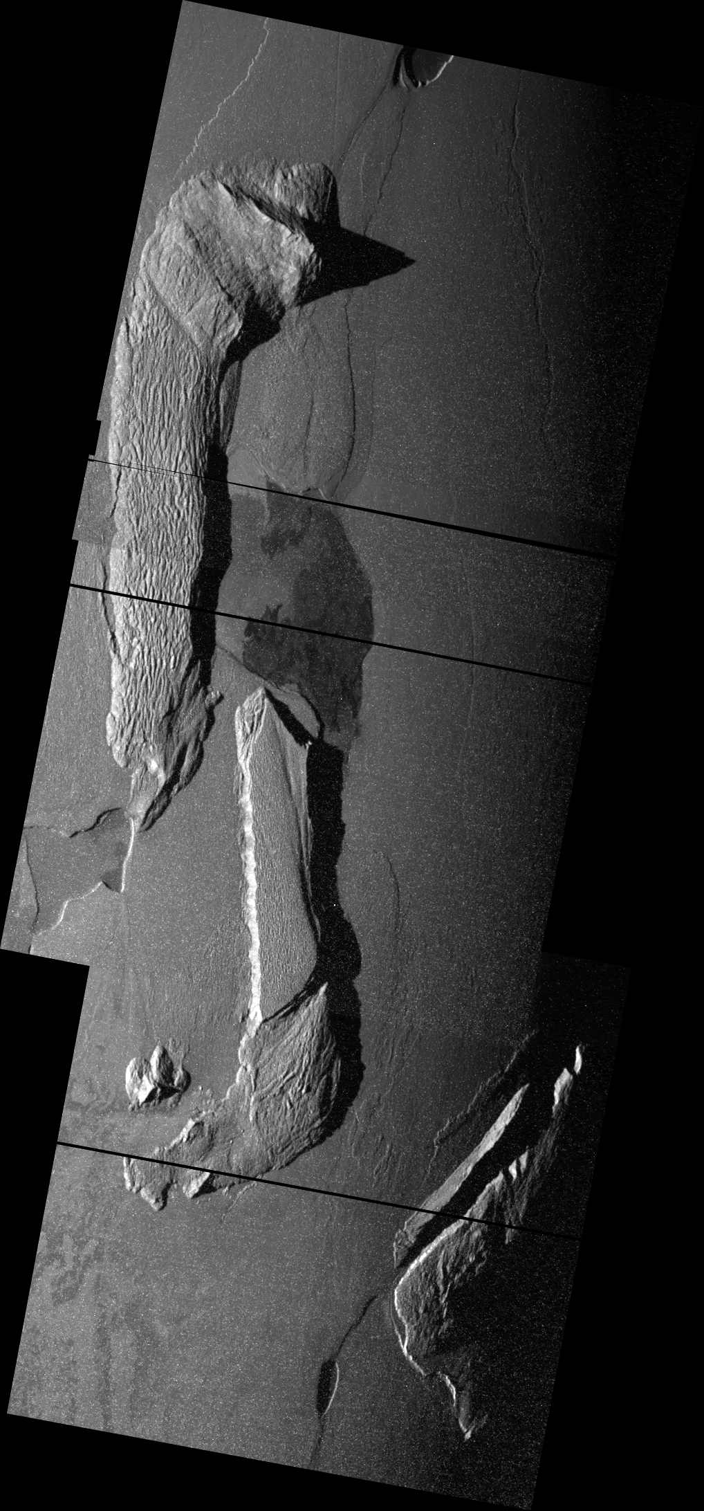
Both regions mapped by the ASU group have complex examples of the interaction between tectonics and volcanism. At Hi'iaka, there are three mountains, two L-shaped mountains named North Hi'iaka Montes (the entirety of which can be seen at right), South Hi'iaka Montes (a degraded plateau to the southeast of the north segment), and West Hi'iaka Montes (a footprint-shaped isolated peak to the southwest of South Hi'iaka). The authors state that their mapping of this part of Io supports the theory that North and South Hi'iaka Montes were once a single mountain that rifted along its long axis (a process seen at several mountains on Io, like North Boosaule Montes and Danube Planum) then underwent right-lateral strike-slip faulting that left mountains in their present locations. The authors then propose that this tectonic motion opened up a depression that would become Hi'iaka Patera. Another interesting tectonic-volcanic interaction in these regions is the extensional fault that NE-SW through Shamshu Mons that also has a small patera along its length (a volcano the authors call Perun Patera, though that name would never be approved since there already is a volcano on Io named after Perun, Pyerun Patera). This, along with the youngest flows within patera following visible fault lines, supports the idea that magma use pre-existing fault lines as conduits for ascent.
 Another theory the authors tested with these maps is whether differences in mountain morphology are related to age and state of degradation. The mountain units types the authors mapped include lineated, mottled, undivided, and plateau mountain material. According to the abstract, "Mapping results support the theory that mountain units can be uplifted and tectonically modified [like the rifting seen at Hi'iaka and Shamshu Montes], then sloped, scalloped, and leveled by SO2 sapping". The authors suggest that the mountains start out lineated with moderate mass wasting but with many of the original imbricate faults and sub-surface layering still visible. These then degrade into undivided mountain material, a combination of mottled and lineated materials, and then mottled material, which contains hummocky material and a patchwork of bright and darkish material. SO2 sapping at Hi'iaka Montes is evidenced by the bright white plains material that follow the slopes of both North and South Hi'iaka, as well as parts of Shamshu Mons.
Overall an interesting paper about a very intriguing region on Io. The only complaint I have is that there really is only one more region to map based on available Galileo imaging -- the area around Tvashtar Paterae.
Link: Geologic Mapping of the Hi'iaka and Shamshu Regions of Io [www.lpi.usra.edu]
Friday, February 6, 2009
LPSC 2009: Argus New Frontiers Mission Concept
 The abstract for this year's Lunar and Planetary Science Conference are now online. LPSC is one of the largest planetary science conferences of the year, along with DPS in the fall and AGU in May and December. This year's Io posters will be a diverse bunch with mission concepts, geologic mapping, and plume modeling, and statistical analyses of Io's landforms on display.
The first LPSC abstract I want to discuss here is titled "Argus: A New Frontiers mission to observe Io" by Nicholas Borer et al. This poster will present a mission concept developed by participants of the 20th Annual Planetary Science Summer School last year. This concept was previously presented at DPS and was briefly discussed here.
The Argus concept shares many similarities with the Io Volcano Observer. Like IVO, Argus would orbit Jupiter and would perform repeated flybys of Io to answer the mission's science questions. These science goals include investigating Io's geology, geochemistry, and atmosphere as well as the process of tidal heating. However, because of the increased cost cap that a New Frontiers AO would afford it, Argus would be able to perform an expanded mission at Io compared to IVO. For example, Argus would fly by Io around forty times over a two-year period, acquiring 6.8 Gb of data each flyby (which is actually only 1/3rd of the planned per orbit data return of IVO, but then again, IVO's orbits at their shortest are three times longer). This would follow a nominal September 2018 launch and a five-year, VVEGA interplanetary trajectory to Jupiter. The instrument payload seems similar to IVO, though Argus would have a Near IR spectrometer for surface compositional measurements and a UV Spectrometer to map the Io Torus and measure the composition of Io's atmosphere and volcanic plumes. Because the magnetic field environment at Io is not a priority for Argus as it is for IVO, Argus doesn't have a magnetometer suite in its concept payload.
Another note about the instruments: BEST...INSTRUMENT NAMES...EVER!! I mean, come on, I-SPI for the visible imager!! CheESE for the near-IR spectrometer! I used to be good at coming up with acronyms. When we were first describing the circular features on Titan that may or may not be impact craters, we needed a term for them that wasn't based on structure since all we saw were near-IR albedo. Zibi Turtle, one of my supervisors, came up with Suspisciously Circular Features (SCFs). Mine was Circular or Round Albedo TERains or CRATERs. Hers was accepted because mine was a bit...too clever. The acronyms for the various instruments seem so creative that I wonder how much time they actually spent sitting around, coming up with acronyms (TIRIMISU, LIME, and SUSHI for the thermal imager, the Ion and Neutral Mass Spectrometer, and the UV Spectrometer, respectively, for the other instruments).
My main concern for this mission is that they used planned heritage from the radiation shielding of Jupiter Europa Orbiter to provide cost savings for the mission to keep it below the New Frontiers cost cap. I guess the other concern would be when this could launch. The next New Frontiers AO will not allow radioisotope-powered missions, only solar-powered ones. While the concept doesn't say what the power source is, the high radiation dosages this mission will receive would seem to preclude solar panels. The abstract does refer to the need to have the spacecraft in safe mode for battery recharging during much of the cruise period of each orbit. Maybe they want to have solar panels that will charge batteries for each flyby, but will then be inactive during the flyby. Not sure how that would keep the panels from being fried by Io's radiation environment. So, assuming it uses radioisotopes for power, Argus would have to compete in the next New Frontiers AO, where it would then have to compete against Argo, a flyby mission of Jupiter, Saturn, and Neptune.
Link: Argus: A New Frontiers mission to observe Io [www.lpi.usra.edu]
LPSC 2009 Abstracts Now Online
Abstracts for this year's Lunar and Planetary Sciences Conference are now online. The final announcement for attendees has also been published.
This year's conference has been moved from South Shore Harbor Resort north to The Woodlands Waterway Marriott Hotel north of Houston, Texas. This year's conference has also been moved to one week later than usual, the week after spring break for many universities. The conference is scheduled for March 23-27, 2009.
Several Io-related abstracts have been submitted for the conference. All but one, that I have found so far, will be presented during the poster session on the evening of Tuesday, March 24. Below is a listing of the Io-related abstracts I have found so far, and links to them.
Over the next few days, I will post discussions of each abstract here on the blog.
This year's conference has been moved from South Shore Harbor Resort north to The Woodlands Waterway Marriott Hotel north of Houston, Texas. This year's conference has also been moved to one week later than usual, the week after spring break for many universities. The conference is scheduled for March 23-27, 2009.
Several Io-related abstracts have been submitted for the conference. All but one, that I have found so far, will be presented during the poster session on the evening of Tuesday, March 24. Below is a listing of the Io-related abstracts I have found so far, and links to them.
Over the next few days, I will post discussions of each abstract here on the blog.
- Volcanism on Io: Insights from Global Geologic Mapping by Dave Williams et al. The blog post covering this abstract is located here.
- Geologic Mapping of the Hi'iaka and Shamshu Regions of Io by Bunte et al. The blog post covering this abstract is located here.
- Classification of Io's Paterae: Active vs Inactive by Barth, Radebaugh, and Christiansen. The blog post covering this abstract is located here.
- Ionian Volcanoes Reveal Their Temperatures by Allen and Radebaugh. The blog post covering this abstract is located here.
- Optimal Wavelengths for Studying Thermal Emission from Active Volcanoes on Io by Keszthelyi, Davies, and McEwen. The blog post covering this abstract is located here.
- Ground-Based Observations of Io in Support of the New Horizons Flyby by Rathbun and Spencer. The blog post covering this abstract is located here.
- Argus: A New Frontiers mission to observe Io by Borer et al. The blog post covering this abstract is located here.
- DSMC Modeling of 3D Vent Geometries for Ionian Plumes by McDoniel et al. The blog post covering this abstract is located here.
- Io Volcano Observer (IVO) by McEwen et al. The blog post covering this abstract is located here.
Thursday, February 5, 2009
More Galileo Maps
 Continuing the project I started last month, I have posted on my Io images page several more Io maps from several of Galileo's orbits, including from G1, C3, G29, and I31. These maps help illustrate some of the surface changes documented by Galileo during its six years of observations while in orbit around Jupiter. For example, comparing the maps from G29 and I31 (shown at right), you can see several new plume deposits, including a bright ring around Thor (which was undergoing a major eruption during August 2001), a red ring around Dazhbog, and a faint deposit around Surt (probably a faded red ring from the major eruption that took place in February 2001, still the most powerful volcanic eruption ever witnessed).
I am still considering producing some sort of product that combines these and other maps of Io as layers in a photoshop file for example. Photoshop isn't quite ArcGIS, but it'll do.
Link: Galileo images of Io [pirlwww.lpl.arizona.edu]
Tuesday, February 3, 2009
New Version of Google Earth with Support for additional Planets
 Yesterday, Google released the fifth version of its popular freeware program, Google Earth. Once of the added features that has caught a lot of attention is the inclusion of Mars and Earth's ocean floor. The Mars addition is particularly fascinating, pulling data from multiple missions (MRO, MGS, Mars Odyssey, and Mars Express) to create a realistic Mars simulator. One of the best features of Google Earth is the flight simulator, which combined with the new "Google Mars", would allows users to fly down Valles Marineris. Though, if they are like me, they crash the simulated plane into the canyon walls.
The new button that allows you to switch between Earth and Mars also seems to imply that other planets, perhaps moons, might be supported in the future. I would certainly love to see "Google Io". However, at this point, stereo data is pretty limited. But it would still be neat.
The image I used from Google Earth above shows the summit crater of Mauna Loa.
Link: Google Earth [earth.google.com]
Sunday, February 1, 2009
Funny Super Bowl Ad
In a Super Bowl filled with mostly lame commercials, there was one stand-out I liked:
Nice space theme, and except for the fact that you couldn't see Saturn's rings like that from one of its moons (or at least none of the ones near enough for Saturn to be that big in the sky) it does look remarkably extraterrestrial. Very nice terrain. Funny commercial. Great ending!
Now if only the Super Bowl had a great ending... unfortunately, this Super Bowl will forever be tainted by that blown call at the end. That, ladies and gentlemen, was a PASS, not a fumble...
Nice space theme, and except for the fact that you couldn't see Saturn's rings like that from one of its moons (or at least none of the ones near enough for Saturn to be that big in the sky) it does look remarkably extraterrestrial. Very nice terrain. Funny commercial. Great ending!
Now if only the Super Bowl had a great ending... unfortunately, this Super Bowl will forever be tainted by that blown call at the end. That, ladies and gentlemen, was a PASS, not a fumble...
Common Features Among Io's mountains
 After this week's Boösaule Montes post, I thought it would be good to do a more general mountain post. I actually think I will write up a few such posts. This first one will discuss common features seen among Io's more than 150 positive-relief features. This post is based on discussion of this topic in "The mountains of Io: Global and geological perspectives from Voyager and Galileo" by Paul Schenk, Henrik Hargitai, Ronda Wilson, Alfred McEwen, and Peter Thomas. This paper was published in the Journal of Geophysical Research in December 2001.
Perhaps the most common attribute of all mountains on Io are that they have experienced some form of degradation. In other words, no mountains appear prestine, despite the relatively young age of Io's mountains. Assuming an average deposition rate across Io surface of one cm per year, every part of Io's surface should be covered in ten km of material in one million years. Ten km is more than the average height of mountains on Io, so most mountains are probably younger than that. Degradation of mountains comes in the form of mass wasting which can take several forms. First, slumping on steep slopes can dislodge large blocks down slope or form thick, fan-shaped deposits. The latter case was mentioned before at Boösaule Montes "South". Slumping on shallower slopes, like on the top of Hi'iaka Montes "North", can form ridges perpendicular to the direction of slumping. The ridges are crumpled up material from the upper layers of the plateau. In other cases, long-runout landslides can result from more rapid mass movement of material. These can form deposits a few-hundred meters thick that can reach as far as a couple hundred km from the mountain.
 A third form of degradation is sapping. Sapping a geologic process by which volatiles exit a slope, usually as a groundwater spring on Earth. On Io, because there is no air pressure to speak of, this process is much more explosive. Sapping is thought to create the spur-and-gully morphology seen on many Ionian plateaus, as seen at Tvashtar Mensae at left. While the sulfur dioxide sublimates away during the explosion, more solid materials is transported downslope, forming deposits a couple hundred meters thick. Again, you can see the leading edge of this deposit at Tvashtar along the bottom right side of the image. At some mountains, sulfur dioxide is released without apparent erosion but instead leaves a bright deposit of frost. This is particularly common at mountains in Io's polar regions, like Haemus Montes, but has been seen in action closer to the equator, such as at Pillan Mons.
 Certain structural features are commonly seen on Io's mountains. For example, striations, representing either pre-existing layers in Io's crust or fault lines from imbricate-style faulting produced during the mountain's uplift, are seen at several mountains such Haemus Montes. Another common feature is central rifting. In this case, the mountain appears as if it has been split apart with a canyon running down the long axis of the feature. This was seen at Boösaule Montes "North" in the earlier post but can also be seen at other mountains such as Pan Mensa and Danube Planum.
Many mountains have structural similarities. There are the low plateaus: relatively flat mesas with smooth or rough top surfaces and steep basal scarps (that are often arcuate as a result of sapping). These plateaus are often two to four km in height. Another interesting mountain type is the double ridge. These mountains have two parallel ridges with a central valley in between. Two examples of an Ionian double ridge include Ionian Mons and Mongibello Mons. Another mountain type is the flatiron, as seen at Gish Bar Mons above. Flatiron mountains have an asymmetric profile, with a relatively shallow slope on one side and steeper, more rugged slopes on the other sides. Schenk et al. surmise that these mountains are produced by thrust faulting with the smooth slope representing the formerly flat surface and the steeper slopes revealing a cross-section of the upper lithosphere of Io. These are the tilted crustal blocks highlighted in Schenk and Bulmer 1998.
 A final common trait among Ionian mountains is their proximity to volcanic depressions, known as paterae, despite not being volcanoes themselves (with a few rare exceptions). An example of this is Gish Bar Mons, whose southern flank is also the northern rim of Gish Bar Patera. According to Schenk et al. 2001, 30% of mountains on Io have flanks within 5 km of paterae. 10% of paterae, according to Radebaugh et al. 2001, lie next mountains. One reason for this correlation may be that magma exploit weaknesses in the crust, including faults associated with mountain building. This process then leads to paterae formation, which if Keszthelyi et al. 2004 is correct, would involve the formation of volcanic intrusions in the upper layers of the crust which then drive off volatiles in the crust above the intrusion and melt the rest, until a depression is formed down to the level of the sill.
In the next Mountains post, which I will try to post sometime later this week, we will look at what the distribution of mountains on Io can tell us about Io's crust.
Thursday, January 29, 2009
Surface Changes on Titan
 Okay, true, Titan is off-topic here but still I can't pass up an opportunity to mention a paper that was published today in Geophysical Research Letters (in which I am second author of) reporting the discovery of active playa in the south polar region of Saturn's moon Titan. We also released a press release on this. While counting and measuring dark features in the south polar region last year in preparation for a Titan paper, I found that some of these features were in one observation from June 2005 but not in the other from July 2004. If these were small features, I could discount them as being due to resolution effects and the effects of the atmosphere that blurs out details, but these changes were much too large. You can see what I am talking about on the Planetary Photojournal.
It didn't take us long to figure out what we were looking at, a real surface change on the surface. We surmise that this change resulted from a rainstorm that dumped enough rain over this spot on Titan to flood the valley floors with a shallow layer of liquid methane. The most likely storm (that we are aware of, keep in mind that we don't have continuous coverage) to have caused this was a massive storm system seen from Earth and by Cassini ISS in early October 2004. The brightest part of the storm (and plausibly the most intense part of the storm with the greatest cloud heights) was located over this surface change in the ISS observation of the storm on October 8, 2004.
Anyways, even though it was off-topic, I thought I would quickly share this here.
Link: Cassini Finds Hydrocarbon Rains May Fill Titan Lakes [ciclops.org]
Subscribe to:
Posts (Atom)


 Posts
Posts