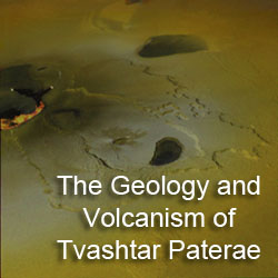
It is four for the price of one for this week's Io Volcano of the Week: Tvashtar Paterae. During the month of August, we have examined the five volcanoes that were imaged up-close by the
Galileo spacecraft during its encounter with Io on November 26, 1999. During that flyby,
Galileo acquired five observations with a scale of 160-280 meters or 525-920 feet per pixel (higher resolution observations were lost due to a spacecraft safing event). Thus far we have profiled
Zal,
Emakong,
Hi'iaka, and
Culann, active volcanoes seen across various parts of Io's leading hemisphere. This week, we travel to the great red north to Io's camera-loving volcano, Tvashtar Paterae. Due to the sheer amount of data acquired of and papers written about just this one volcanic region, I am going to split this discussion up in to (at least) three parts. Today, we will examine the geology of Tvashtar Paterae and the surrounding region, as well as the imagery
Galileo returned of this volcano.
Tomorrow, August 31, we will focus on the eruptions that occurred at Tvashtar during the
Galileo mission. Finally, on
Wednesday, September 1, we will examine the volcanic eruptions that have occurred there since the end of the mission, including the massive one that happened during the
New Horizons flyby, and what these various eruptions tell us about how Tvashtar's lavas are supplied.
First, let's stick to the basics.
Tvashtar Paterae is a chain of volcanic depressions located at 62.76° North Latitude, 123.53° West Longitude, placing it in the high northern latitudes of Io's anti-Jovian (i.e. the "far" side) and leading hemispheres. All together, Tvashtar measures 306 kilometers (190 miles) from its northwest to southeast ends. The volcanic region is named after Tvastar, a solar deity and blacksmith to the gods of the
Vedic religion. Tvastar crafted, like Hephaestus for Zeus in Greek mythology, the thunderbolts of Indra and other magical implements. There are a number of Ionian volcanoes named after characters from Vedic and Hindu religious texts, such as Savitr (a large volcanic depression 300 kilometers, or 186 miles, south of Tvashtar), Surya, Vivasvant, Arusha, and Agni. Originally, the region was named
Tvashtar Catena in 2000, using the
IAU term for a string of craters, but that feature type was deprecated for Io in 2006, so the descriptor term was changed to the plural of patera (technically, an irregular depression, but
used for Io as a geologic term for a volcanic depression).
Images
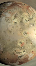
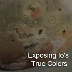
Before we get to the geology of Tvashtar Paterae, let's take a look at the available imagery, which you will see a lot of over the next few days on this blog. While it was clearly visible in global-scale images taken by the
Voyagers and
Galileo before (including the
C21 global color mosaic, a portion of which is shown at the top of this article), Tvashtar was first imaged up-close on November 26, 1999 during
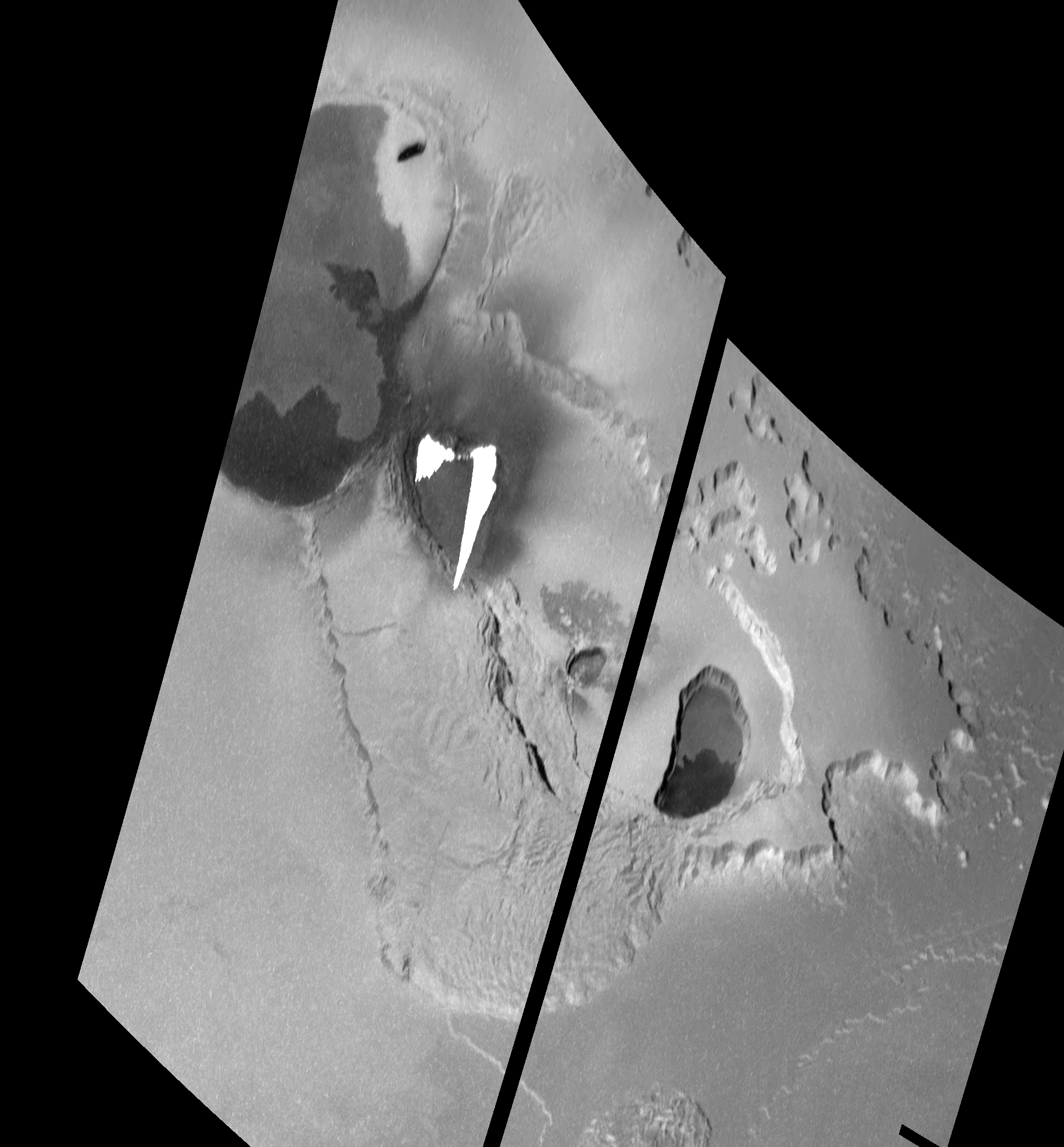
Galileo's I25 flyby. This two-frame mosaic, with a scale of 183 meters (600 feet) per pixel, was originally designed as a 2 frame-by-4 frame mosaic that covered both Tvashtar and
Savitr Patera to the south. The goal was to better understand the geology of giant paterae (i.e. volcanic depressions) that appeared to be common across Io's polar regions. Based on measurements made by Jani Radebaugh and her colleagues and published in 2001, the paterae at high latitudes are larger but less numerous, and these two large depressions were thought to be typical of this. Their eruption style also seemed to differ from volcanoes observed at lower latitudes. 25ISGIANTS01 was trimmed down to a 2-frame mosaic covering only Tvashtar Paterae in late October 1999 after the I24 flyby when the malfunction of the camera's summation mode meant that fewer frames could be taken given the available downlink. Frames also had to be cut because of the decision to use pre-downlink compression off the tape recorder, rather than the camera's on-board compression, for some of the images taken. The observation was returned slowly during December 1999, revealing a violent new eruption in the Tvashtar region.
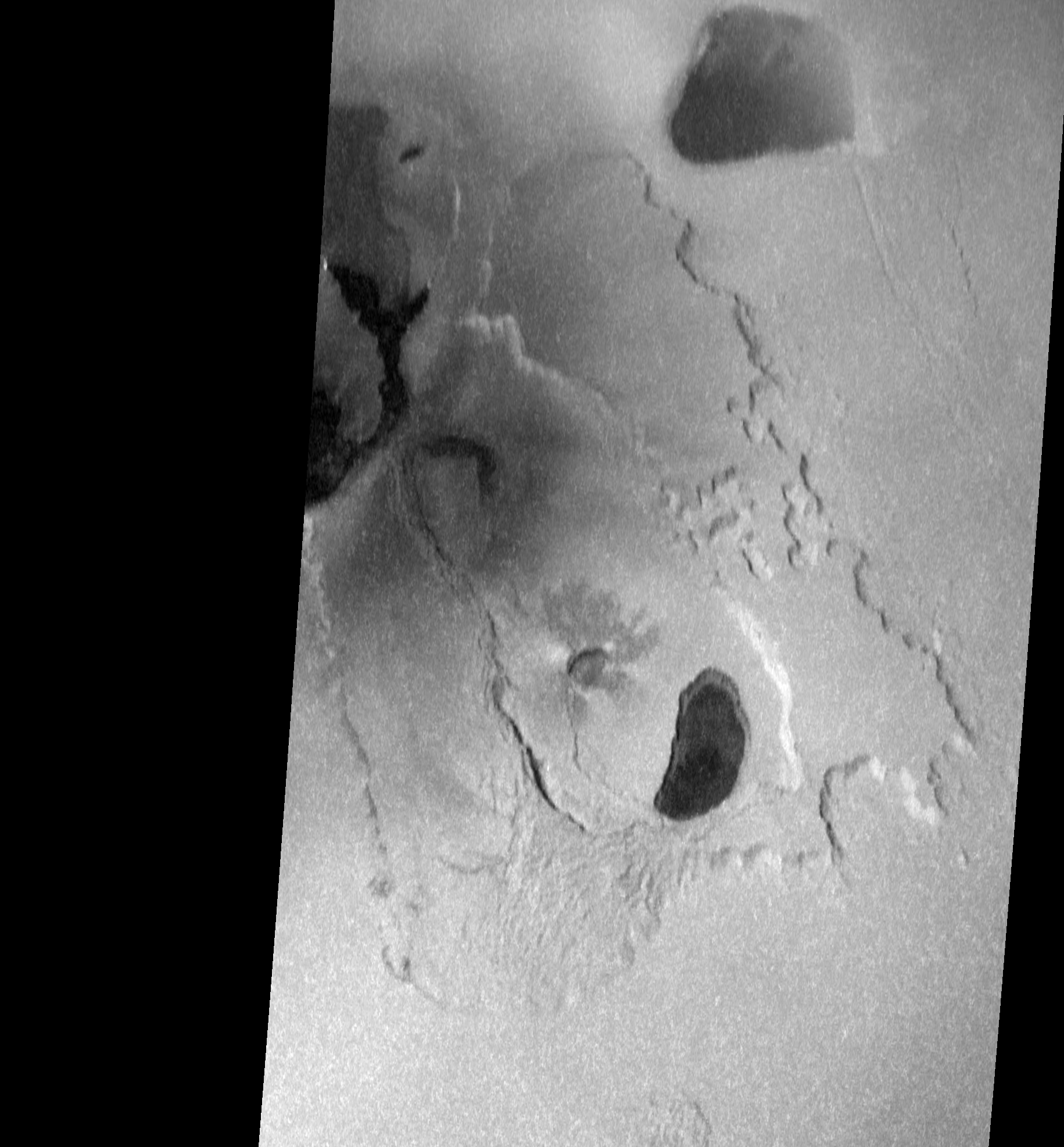
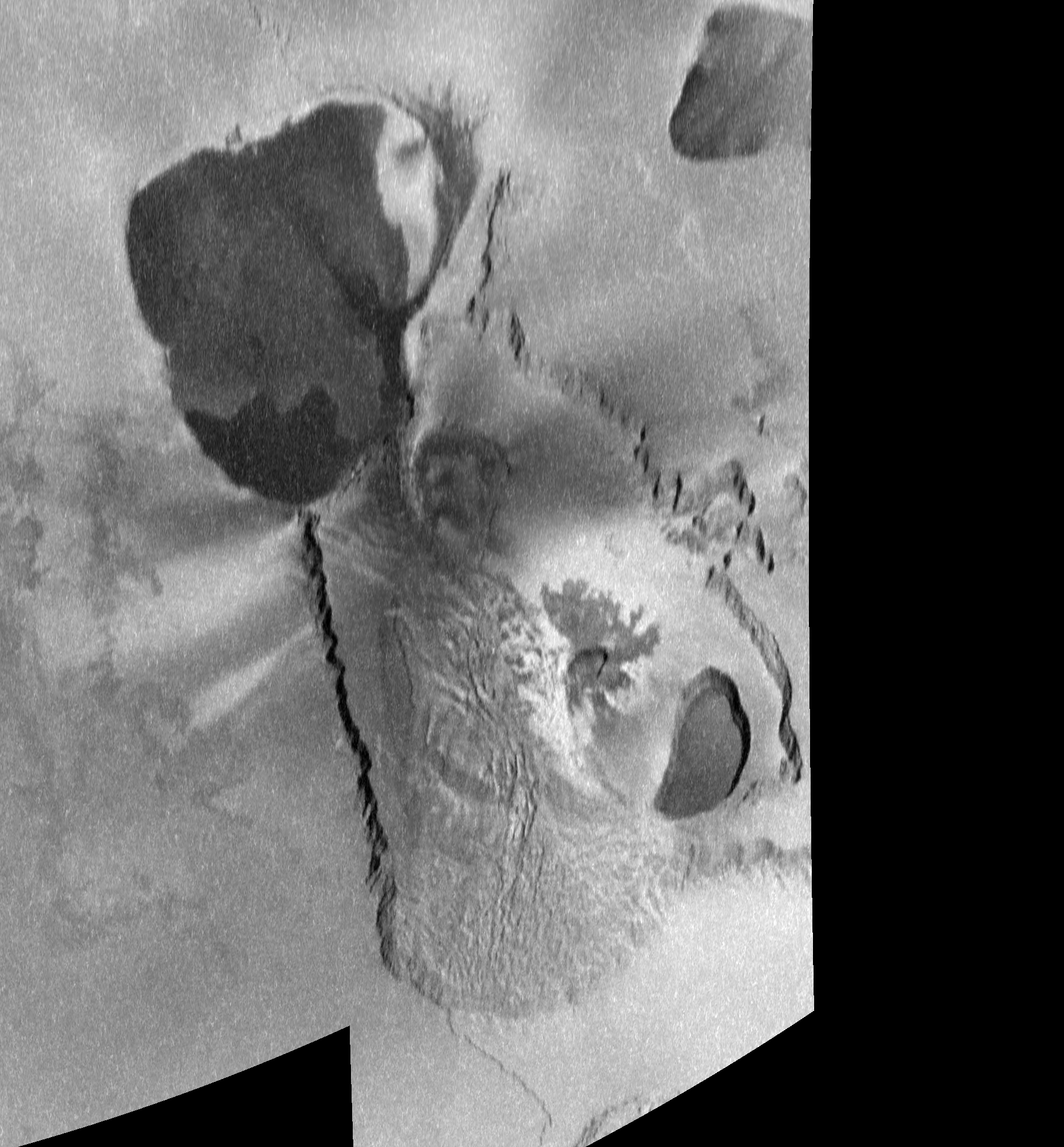
As a result of the eruption there, Tvashtar was targeted for imaging on three of
Galileo's four remaining Io flybys, in order to look for new activity and to monitor the region for surface changes. The two datasets that made it back it to Earth include a five-color observation from the I27 encounter (February 22, 2000) and a two-frame, clear-filter mosaic from the I32 flyby (October 16, 2001). The first observation, 27ISTVASHT01, has a scale of 315 meters (1,033 feet) per pixel, while the second, 32ISTVASHT01, has a pixel scale of 200 meters (656 feet). Higher resolution imaging was planned for an encounter in August 2001, however they were lost due to a camera anomaly. These included a very high resolution mosaic that would have covered the I25 eruption site and nearby patera wall at 3-5 meters (10-16 feet) per pixel.
 |  |  |
| 25ISGIANTS01 - 11/26/1999 | 27ISTVASHT01 - 02/22/2000 | 32ISTVASHT01 - 10/16/2001 |
The three returned data sets are shown above. Each has been reprojected to an orthographic map projection centered on Tvashtar. The scale is 200 meters (656 feet) per pixel. Finally, the resulting mosaics were cropped so that they cover the same area to make comparisons easier.
Geology
Tvashtar Paterae is not a single volcano, but a chain of four separate volcanic centers. A rough schematic based on the three data sets is shown at right. Orange lines mark the margins of volcanic depressions. Blue lines mark the edges of plateaus, while green lines mark the visible edges of landslide debris deposits. From this image, we can see that Tvashtar can be broken up into roughly two parts. The northern end of Tvashtar consists of a large, 145
×105-kilometer (90
×65-mile), heart-shaped depression and is located at
64.7° North Latitude, 127.0° West Longitude. This low-depression is host to a large area of dark material, with the darkest of this distributed in a whale-shaped region along the southern and eastern margin of the patera, though an additional very dark region was also seen in the western portion of the patera in July 1999, but had brightened by October 2001. The green color of the rest of the dark terrain of this patera suggest that it consists of older lava or pyroclasts that have been modified chemically by infalling sulfur and sulfur dioxide, creating a film of iron sulfide. High-resolution color observations from I27 revealed a bright deposit along the northeastern wall of this patera, possibly resulting from sulfur dioxide sapping, a geologic process we will encounter often as we explore the geology of Tvashtar, or
fumaroles.
The southern end of Tvashtar consists of a 196
×70-kilometer (121×44-mile), footprint-shaped region that is almost entirely enclosed by a low, U-shaped plateau named Tvashtar Mensae. This area may be closed off by a patera wall to the northwest as well, but it is not clear if this region is lower than the local Ionian plains. I do not consider this in-and-of-itself a separate volcano. Nested within this region are three smaller paterae, each with signs of recent volcanic activity. Going from west to east, the first nested patera is located at 62.5° North Latitude, 123.2° West Longitude and is 49 by 32 kilometers (30 by 20 miles) in size. A
fissure along the northern margin of this volcano was the site of violent volcanic eruptions in November 1999 and February 2007. Lava flows associated with the 1999 eruption, earlier eruptions over the same place (if you look at the July 1999 images) and later eruptions are visible on the patera floor. This patera is surrounded by a dark (occasionally dark green) pyroclastic deposit that reaches out at least 30 kilometers (20 miles) from the edge of the volcano. The area covered by this deposit grows and shrinks in places over the period from 1999-2001, suggesting that volcanic activity leaves behind these deposits in the present epoch and sulfur dioxide released by sapping from the base of Tvashtar Mensae obscures some of it over time.
The second volcano is located at
60.6° North Latitude, 120.4° West Longitude and is 14 by 8 kilometers (9 by 5 miles) in size. This patera is surrounded by digitate lava flows, suggesting that in the past it filled with lava and overflowed onto the surrounding landscape, mostly to its north and east. Finally, the third patera is located at
59.6° North Latitude, 117.9° West Longitude and is 49 by 27 kilometers (9 by 5 miles) in size. Unlike the rest of Tvashtar's constituent paterae, this volcano is bounded by steep cliffs, with a shelf forming a low ledge at its base. This shelf may have formed when some of the lava that once filled the patera to a bit higher up the patera wall than it does today drained back down into the shallow magma reservoir. Through Galileo's February 2000 observations, the southern half of this patera was covered with dark lava, while the northern half was covered with brighter green material, again thought to be chemically-altered basalt.
On-going volcanic activity was detected at all four volcanoes of Tvashtar Paterae at one time or another by
Galileo, ground-based telescopes, and
New Horizons. This activity will be discussed in later posts this week.
I should also discuss the plateau that surrounds most of Tvashtar Patera. This U-shaped mountain, Tvashtar Mensae, is named after the chain of volcanoes it nearly surrounds. It can be roughly split into eastern and western halves. The eastern half is a smooth, flat plateau that rises approximately 2 kilometers (6,600 feet) above the surrounding plains. The cliffs that run along the edge of this plateau are marked by large alcoves that give it a spur-and-gully pattern. These alcoves grow into large canyons in several spots that penetrate as deep as 40 kilometers (25 miles) into the plateau. These canyons also include small mesas. Running outward from the outer margins of the mesa is a low debris field that is a few hundred meters above the surrounding plains. These morphological characteristics suggest that the mesa has been heavily modified by sulfur dioxide
sapping. As
I discussed a few days ago, sapping occurs when frozen or liquid sulfur dioxide escapes from the base of a slope on Io and is deposited as a layer of
sulfur dioxide frost as much as 70 kilometers (45 miles) away from the cliff. This process can undermine the slope above where the sapping occurred, causing it to collapse and form a gully along the cliff face. Repeated sapping events can cause the slope to retreat. Uneven slope retreat caused by excess sapping in one area, perhaps due to heating from below, can result in the formation of the wide-mouth canyons visible at Tvashtar Mensae and create small mesas, remnant portions of the plateau that have been cut off by sapping and slope retreat,
not unlike the one discussed the other day. Sapping and slope retreat can be sped up by heat from sub-surface magma or an interbedded
sill. This may be responsible for the U-shape of Tvashtar Mensae, as increased heat flow in the area promotes the removal of material from plateau, eating away at it and forming the eastern half of Tvashtar Paterae. Material that didn't become vaporized during the sapping events and
mass wasting events form the
hummocky debris deposits to the east and north of Tvashtar Mensae.
The western half of Tvashtar Mensae has a very different morphology. Rather than being flat and smooth, the western half is rougher and rises nearly 6 kilometers (19,700 feet) above the surrounding plains in places. The rough texture of its surface suggests that it has slumped outward since it formed, creating a lobate landslide deposit off the eastern side of the mountain, on the floor of the southern "patera" of Tvashtar Paterae. The 2 kilometer (6,600 feet)-tall cliff that bounds the western edge of the mountain has a regular arcuate margin that is explained more easily by simple mass wasting through slumping and small landslide events, rather than sapping like the eastern half of Tvashtar Mensae. This close connection between a tall mountain, perhaps created by thrust faulting, and a lower smooth mesa has been seen at several other locations across Io, including
Zal Montes, where the two components may have broken apart by strike-slip faulting.
The geology of the Tvashtar region is strongly affected by the volcanic activity that occurs there.
Galileo,
New Horizons, and ground-based telescopes have observed major volcanic eruptions at Tvashtar on several occasions since 1999. Over the next two posts, we will examine the volcanic history of Tvashtar Paterae.
Tomorrow, we will focus on the volcanic activity observed at Tvashtar between 1999 and 2001.
On Wednesday, we will look at more recent activity in 2006 and 2007, including the incredible volcanic plume seen by New Horizons. I hope you enjoy!
References:
Keszthelyi, L.;
et al. (2001). "
Imaging of volcanic activity on Jupiter's moon Io by Galileo during the Galileo Europa Mission and the Galileo Millennium Mission".
Journal of Geophysical Research 106 (E12): 33,025–33,052.
Radebaugh, J.;
et al. (2001). "
Paterae on Io: A new type of volcanic caldera?".
Journal of Geophysical Research 106 (E12): 33,005–33,020.
Turtle, E.;
et al. (2004). "
The final Galileo SSI observations of Io: orbits G28-I33".
Icarus 169: 3–28.
Milazzo, M.;
et al. (2005). "
Volcanic activity at Tvashtar Catena, Io".
Icarus 179: 235–251.
Moore, J.;
et al. (2001). "
Landform degradation and slope processes on Io: The Galileo view".
Journal of Geophysical Research 106 (E12): 33,223–33,240.
Schenk, P.;
et al. (2001). "
The mountains of Io: Global and geological perspectives from Voyager and Galileo".
Journal of Geophysical Research 106 (E12): 33,201–33,222.


What a great post. It might be neat to add the C3 and C21 views to the comparison row.
ReplyDeleteHow's this: http://www.gishbartimes.org/2010/09/remains-of-week.html
ReplyDelete