
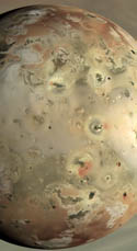
 As I mentioned yesterday, one of the little side projects I have been working on has been to create color maps of Io for each Galileo orbit we have color data from (though I did create a clear filter map from C3). This would allow for easier comparisons between Galileo orbits of Io's surface changes (though note that Io has some funky phase angle brightness changes between different regions on the surface that can complicate matters).
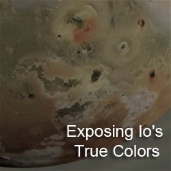
This evening, I finished the maps for G7 (April 1997) and I32 (October 2001). The other maps can be found by browsing my Galileo Images of Io website. With these two maps, I have expanded the cutoff I use to trim the images in both incidence angle (an angular measure of distance from the sub-solar point) and emission angle (an angular measure of distance from the sub-spacecraft point). So these new maps show features a little closer to the terminator and limb, respectively, than before. I think the numbers I am using now for the lunar-lambert function seem to be a better fit than what I used before, making this possible (basically 0.2 above what I would have used before).
I think this is the last pair for a little while. Cassini is really starting to heat back up again with data coming down in a few hours (sleep for me tonight will be a cat-nap really...) from encounters with Aegaeon (yes, Joe, those six pixels are what I am looking for the most...), Prometheus, and Dione. Later today we have a Titan flyby where ISS will be prime at closest approach for one of two times during the extended mission. So yeah... :-) I will try to get another post out about one of the LPSC abstracts later today if I have some time.
Link: Galileo Images of Io - G7 [pirlwww.lpl.arizona.edu]
Link: Galileo Images of Io - I32 [pirlwww.lpl.arizona.edu]


Hi, I love reading the Gish Bar Times! I am currently working on a project with mapping a portion of Io as well. Where did you get the information for the emission angle and incidence angle? I specifically need this information for the I32 flyby. Is this information accessible to college students. Thanks again!
ReplyDelete